Tag Archives: Driving

The New York Times Magazine- January 14, 2024

Image

THE NEW YORK TIMES MAGAZINE (January 12, 2024): The new issue features ‘Why Are American Drivers So Deadly’ – After decades of declining fatality, dangerous driving has surged again….

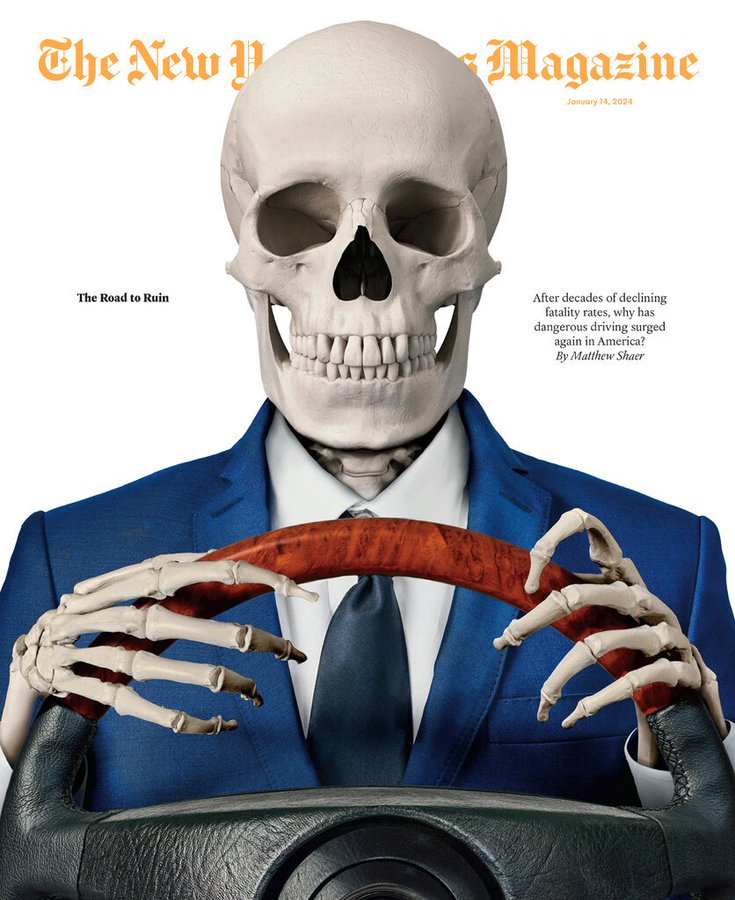
Why Are American Drivers So Deadly?

A photo illustration of a skeleton in a suit driving a car.

After decades of declining fatality rates, dangerous driving has surged again.

By Matthew Shaer

In the summer of 1999, a few years after graduating from medical school, Deborah Kuhls moved from New York to Maryland, where she had been accepted as a surgical fellow at the R Adams Cowley Shock Trauma Center in Baltimore. Founded by a pioneer in emergency medicine, Shock Trauma is one of the busiest critical-care facilities in the country — in an average year, doctors there see approximately 8,000 patients, many of them close to death.

The All-Time-Great Coach Who Makes Football Fun

Andy Reid with Mahomes and other Chiefs players.

Andy Reid’s diligence and sense of mischief have made him one of the game’s best-ever coaches. Can he get his struggling Chiefs back to the Super Bowl?

By Michael Sokolove

Andy Reid, the coach of the Kansas City Chiefs, has won more than 250 games in his career, fourth all-time, which puts him high on any list of the N.F.L.’s greatest coaches. Most of the others in that pantheon are men who personify the sport’s militaristic soul — Vince Lombardi, for example, the fabled coach of the 1960s-era Green Bay Packers, or Reid’s contemporary, the grim Bill Belichick of the New England Patriots. But Reid is no Lombardi or Belichick; he’s Steve Jobs. He’s a designer, a tinkerer, a product engineer who imbues his football with creativity and even an occasional touch of whimsy.

Cinematic Travel: A Road Trip Through Malaysia

Curves Magazin – A roadtrip through northern and southern Malaysia starting in Kuala Lumpur.

Kuala Lumpur, capital of Malaysia. The city is located in west-central Peninsular (West) Malaysia, midway along the west coast tin and rubber belt and about 25 miles (40 km) east of its ocean port, Port Kelang, on the Strait of Malacca. It is the country’s largest urban area and its cultural, commercial, and transportation centre. In 1972 Kuala Lumpur was designated a municipality, and in 1974 this entity and adjacent portions of surrounding Selangor state became a federal territory.

Kuala Lumpur lies in hilly country astride the confluence of the Kelang and Gombak rivers; its name in Malay means “muddy estuary.” Malaysia’s Main Range rises nearby to the north, east, and southeast. The climate is equatorial, with high temperatures and humidity that vary little throughout the year. The area receives about 95 inches (2,400 mm) of rain annually; June and July are the driest months. Area federal territory, 94 square miles (243 square km). Pop. (2009 est.) city, 1,493,000; (2020) federal territory, 1,982,112.

Photography: ‘Mountain Roads’ By Stephan Bogner & Jan Baedeker (2021)

The new book «Mountain Roads» by photographer Stefan Bogner and author Jan Baedeker is a 496-page tribute to the world’s most beautiful hairpins, serpentines, and alpine roads.

The mountain was there yesterday. And it’ll be there tomorrow. It has no interest in us. Its sense of time is geological, we’re little more than a moth that has landed on its broad flanks a moment ago: the prehistoric hunters, the Roman legions, the pilgrims and medieval traders, the road builders with their dynamite, the royal carriages, the puffing steam trains, the freezing soldiers with their rifles, the first motorists wrapped in clouds of dust and the echo of their engines, the cyclists and their iron thighs and tight trousers, the honking postal coaches, motor-homes and buses, the roaring racing machines – the mountain couldn’t care less. Mule tracks, military thoroughfares, trade routes, panoramic roads – merely fleeting shadows on its elephant skin. When a wave of rock piles up and breaks in the slowest of all slow motion for a billion years – what then is a decade, a century, a millennium? 

Read morehttps://www.classicdriver.com/en/article/travel/ultimate-book-about-mountain-roads-big-and-heavy-a-rock

Future Of Safe Driving: ‘Infrared & Iris Sensors’

The SEAT Smart Quality team uses Eye-Tracker glasses to track the driver’s gaze through infrared sensors, cameras and algorithms. Knowing where users are looking helps to achieve a more intuitive and secure interaction with devices such as infotainment.

This technology will have applications in other areas such as the design of mobility apps. Infrared light sensors, high resolution images and a sophisticated algorithm. All this technology is used to find out exactly where people are looking.

As we drive, the road must obviously be the main focus. That’s why it’s key to safety to be able to locate everything we’re looking for on the central console of the infotainment system at a glance, from the navigation system to the air conditioning or the radio.

 “We must guarantee the minimum interaction time with the screen, and to do this the information must be where users intuitively and naturally look for it” says Rubén Martínez, head of SEAT’s Smart Quality department. To accomplish this, they now have an innovative system.

Smartphone Apps: ‘The Rise Of Google Maps’ (Video)

Google Maps has taken on competitors like MapQuest, Yahoo and Apple. But after a decade of investing, collecting data and billions of images through Street View, Google has over a billion monthly users. It updated tens of thousands of times a day and has mapped more than 220 countries and territories. Here’s a look at how Google came to dominate maps.

Driving Tour: ‘Big Sur Highway 1 To Carmel’ In California (Video)

Big Sur Coast Highway is a section of California State Route 1 through the Big Sur region of California that is widely considered to be one of the most scenic driving routes in the United States, if not the world. It is both a National Scenic Highway and a California Scenic Highway, and was described by Australian painter Francis McComas as the “greatest meeting of land and water in the world.”[4] Condé Nast Traveler named State Route 1 through Big Sur one of the top 10 world-famous streets, comparable to Broadway in New York City and the Champs-Élysées in Paris.

The Big Sur portion of Highway 1 is generally considered to include the 71-mile (114 km) segment adjoining the unincorporated region of Big Sur between Malpaso Creek near Carmel Highlands[2] in the north and San Carpóforo Creek near San Simeon in the south.[3]

Investigations: ‘Why Premium Gas Is A Waste Of Money’ (CNBC Video)

Gas prices have been relatively low compared with the airy peaks they had seen roughly a decade ago; Americans are paying more for premium gasoline than standard gasoline than they have in the past. According to AAA, Americans collectively waste $2 billion a year buying premium gasoline. The critical difference between premium gas from regular is its octane rating—understanding that octane rating and what cars need what gasoline is key to knowing whether it is worth paying for premium.