Insider Business (April 21, 2023) – For generations, farmers in Indian-administered Jammu and Kashmir have been selling their crops on the Dal Lake in a floating market. The lake is an economic hub for people living there – with many working in agriculture, fishing, and tourism. But decades of pollution have threatened their livelihoods.
The floating vegetable market on Dal Lake is in Srinagar, Kashmir, where locals trade out of their canoes. The produce sold here is grown in floating gardens.. The rich ecosystem of this wetland produces plenty of tomatoes, cucumbers, water chestnuts and the famous nadru (lotus roots, a delicacy in the Kashmir Valley).
They gather in the centre of the lake at dawn, and disappear just as sunlight hits the waters.
April 15, 2023: An aerial journey through some of Slovenia’s most scenic locations, including the majestic Julian Alps, the picturesque Lake Bled, and the emerald green Soča River. You will witness the stunning beauty of the Slovenian countryside from a unique perspective, as my drone soars high above the mountains, forests, and lakes.
AirPano VR (March 31, 2023) – Lake Hibara is a lake located in Yama District, Fukushima, Japan. It is a part of the Bandai-Asahi National Park and is the largest of the lakes in the Bandai-kōgen plateau.
A mesotrophic lake, Lake Hibara was formed as a result of the July 15, 1888 eruption of Mount Bandai. The resulting debris avalanche created a natural dam that then filled with water, submerging Hibara Village.The remains of Hibara Village still lie at the bottom of the lake.
Curves Magazin (March 20, 2023) – An epic road trip through Patagonia in Southern Argentina.
Patagonia, semiarid scrub plateau that covers nearly all of the southern portion of mainland Argentina. With an area of about 260,000 square miles (673,000 square kilometres), it constitutes a vast area of steppe and desert that extends south from latitude 37° to 51° S.
It is bounded, approximately, by the Patagonian Andes to the west, the Colorado River to the north (except where the region extends north of the river into the Andean borderlands), the Atlantic Ocean to the east, and the Strait of Magellan to the south; the region south of the strait—Tierra del Fuego, which is divided between Argentina and Chile—also is often included in Patagonia.
Desert and semidesert cover the Patagonian tableland that extends from the Andes to the Atlantic Ocean. The general aspect of this tableland is one of vast steppelike (i.e., virtually treeless) plains, rising in terrace fashion from high coastal cliffs to the foot of the Andes; but the true aspect of the plains is by no means as simple as such a general description would imply. The land along the Negro River rises in a series of fairly level terraces from about 300 feet (90 metres) at the coast to about 1,300 feet at the junction of the Limay and Neuquén rivers and 3,000 feet at the base of the Andes. The tableland region rises to an altitude of 5,000 feet.
South of the Negro River, the plains are much more irregular. Volcanic eruptions occurred in this area until fairly recent times, and basaltic sheets covered the tableland east of Lakes Buenos Aires and Pueyrredón. Near the Chico and Santa Cruz rivers, the plains have spread to within about 50 miles (80 kilometres) of the coast and reach almost to the coast south of the Coig and Gallegos rivers. In places, basaltic massifs (mountain masses) are the salient features of the landscape.
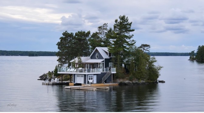
Muskoka Lakes is cottage country paradise. Miles of boating, natural wonders, a vibrant history and a superb quality of life attract visitors from around the world. It is comprised of 80 lakes, including the three big lakes that define the Muskoka experience: lakes Muskoka, Rosseau and Joseph.
Muskoka’s steamship heritage is older than Canada. The first ship steamed Lake Muskoka in 1866. In 2017, the RMS Segwun’s marked 130 years of history. She is North America’s oldest operating mail steamship. Wenonah II, a modern interpretation of a traditional steamship, is named in honour of Wenonah, the first steamship to sail Lake Muskoka. In 1887, long before the era of modern highways, the R.M.S. Segwun was built in Glasgow, Scotland, and assembled at Gravenhurst.
The ship was originally a side paddlewheel steamer named “Nipissing II” and served as a connection – transporting passengers, mail, and freight from Muskoka Wharf in Gravenhurst to cottages, resorts and homes that were beginning to populate the Muskoka Lakes
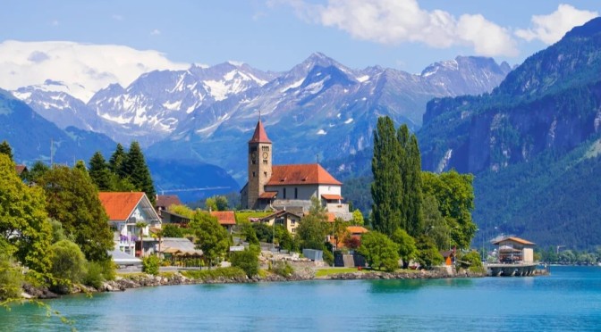
Brienz is a village on the northeast shore of Lake Brienz, in Switzerland’s Bernese Oberland region. The village’s 18th-century wooden chalets and the sculptures dotted throughout the village are testimonials to a woodcarving tradition. North, a steam train runs up Brienzer Rothorn Mountain, with views of the lake and surrounding Alps. East of Brienz, the Ballenberg Open Air Museum offers glimpses of rural life.
The most romantic part of Brienz is the Brunngasse which, having once been awarded the title «most beautiful street in Europe», is well-known abroad. Most of the houses in the street date from the 18th century and are decorated with wood carvings. Brienz, which is well-known as the “village of carving” has a long tradition in wood processing and to this day has a school for carving and violin-making.
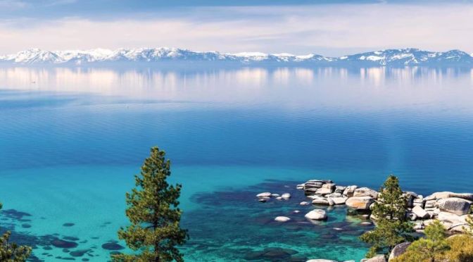
Lake Tahoe is a large freshwater lake in the Sierra Nevada Mountains, straddling the border of California and Nevada. It’s known for its beaches and ski resorts.
Video timeline: South Lake Tahoe(4:45), Emerald Bay(16:25), Meeks Bay(18:15), Homewood(19:10), Tahoe City(19:43), Truckee(20:29), Tahoe Vista(21:48), Kings Beach(22:12), Crystal Bay, NV(23:22), Incline Village(24:01), Sand Harbor(26:23)
On the southwest shore, Emerald Bay State Park contains the 1929 Nordic-style mansion Vikingsholm. Along the lake’s northeast side, Lake Tahoe Nevada State Park includes Sand Harbor Beach and Spooner Lake, a gateway to the long-distance Tahoe Rim Trail.
“Sunday Morning” takes us to San Juan National Forest in Colorado. Videographer: Scot Miller.
The San Juan National Forest covers the southern half of the massive and complex San Juan Mountains. There are numerous peaks, rivers, lakes, and remote stretches in the forest, including the Weminuche Wilderness, the largest in the state. Parts of the forest are accessible from Cortez, Durango, Pagosa Springs, Silverton, Telluride, and Ouray.
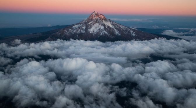
Oregon, constituent state of the United States of America. Oregon is bounded to the north by Washington state, from which it receives the waters of the Columbia River; to the east by Idaho, more than half the border with which is formed by the winding Snake River and Hells Canyon; to the south by Nevada and California, with which Oregon shares its mountain and desert systems; and to the west by the Pacific Ocean, which produces the moderate climate of Oregon’s western lands. The capital is Salem, in the northwestern part of the state.
Video timeline: 0:00 Intro of oregon 0:40 Aerial view of smith rock 1:05 Oregon portland at sunset 1:27 Rocky mountain 1:32 Caruthers bridge in 1:40 Stream and mounta in portland 1:50 Newport oregon 2:04 Beautiful crater lake 2:13 Mt hood & mountain 2:19 Oregon portland at night 2:31 Crater lake with snowy mountain 2:39 Ocean with wave 2:48 Aerial ocean 2:53 Aerial oregon and snowy mountain 3:08 Green fields with lake 3:15 Natural landscape 3:29 Golf course 3:38 Lake view at sunset time 3:47 Oregon eugene 3:57 Covered bridge 4:01 Oregon lake 4:29 Aerial oregon 4:29 Sunset and sonwy mountain 4:42 Oregon field 4:47 Oregon eugene 5:03 Oregon waterfall 5:16 Smith rock aerial view 5:46 Rocky shoreline 5:58 Mt bachelor 6:15 Snowy mountains 6:20 Portland at sunset 6:49 Mountain 6:56 Skyscraper in oregon 7:26 Mountain and field 7:36 Skyscraper in oregon, USA 8:00 Waldport oregon 8:08 Colorful sunset 8:12 Aerial view mountain 8:20 Canon beach 8:45 Crater lake 8:56 Canon beach 9:26 Beach oregon 9:38 Crater lake 10:01 Deschutes river 10:31 Mt hood 10:46 Paddle board 10:54 Oregon eugene 11:23 Oregon clear lake 11:56 Mountainside 12:01 Rocky ocean 12:14 Mt bachelor 12:32 Aerial view of portland, USA 12:44 Snowy oregon 13:03 Lake of oregon 13:24 Waterfall in oregon 13:38 Smith rock 14:07 Mount hood 14:27 Painted hills 14:42 Mt bachelor 14:59 Relaxing river & rock 15:09 Oregon mt bachelor 15:30 Oregon rocky hill 15:50 Oregon portland 16:12 Oregon smith rock 16:42 Oregon skyscraper 17:12 Downtown in Oregon 17:42 Aerial Oregon 18:09 Smith rock 18:29 Aerial skyscraper
Admitted to the union as the 33rd state on February 14, 1859, Oregon comprises an area of startling physical diversity, from the moist rainforests, mountains, and fertile valleys of its western third to the naturally arid and climatically harsh eastern deserts.
Mountains, plateaus, plains, and valleys of different geologic ages and materials are arrayed in countless combinations, including such natural wonders as the Columbia River Gorge, Oregon Caves National Monument, Crater Lake National Park, the majestic snow-covered peaks of the Cascade Range, and the central Oregon “moon country” (lava fields that served as a training site for astronauts in the U.S. space program in the 1960s). The name Oregon is thought to be Native American in origin.
Dufweholms Herrgård is a romantic manor hotel located just outside Katrineholm.
Katrineholm is a locality and the seat of Katrineholm Municipality, Södermanland County, Sweden with 24,271 inhabitants in 2018. It is located in the inland of Södermanland and is the third largest urban area in the county after Eskilstuna and county seat Nyköping.
News, Views and Reviews For The Intellectually Curious


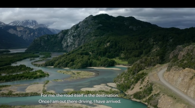
 Curves Magazin (March 20, 2023) – An epic road trip through Patagonia in Southern Argentina.