

Denver, the capital of Colorado, is an American metropolis dating to the Old West era. Larimer Square, the city’s oldest block, features landmark 19th-century buildings. Museums include the Denver Art Museum, an ultramodern complex known for its collection of indigenous works, and the mansion of famed Titanic survivor Molly Brown. Denver is also a jumping-off point for ski resorts in the nearby Rocky Mountains.
Tag Archives: Aerial Views

Aerial Views: ‘Icebreakers & Ships’ Of The Arctic (4K)
The Icebreaker and ships in Artic, cinematic drone footage in 4K by Oculus Films.
The Arctic is a polar region located at the northernmost part of Earth. The Arctic consists of the Arctic Ocean, adjacent seas, and parts of Alaska (United States), Canada, Finland, Greenland (Denmark), Iceland, Norway, Russia, and Sweden. Land within the Arctic region has seasonally varying snow and ice cover, with predominantly treeless permafrost (permanently frozen underground ice) containing tundra. Arctic seas contain seasonal sea ice in many places.
The Arctic region is a unique area among Earth’s ecosystems. The cultures in the region and the Arctic indigenous peoples have adapted to its cold and extreme conditions. Life in the Arctic includes zooplankton and phytoplankton, fish and marine mammals, birds, land animals, plants and human societies. Arctic land is bordered by the subarctic.
The Arctic Ocean is the smallest and shallowest of the world’s five major oceans. It spans an area of approximately 14,060,000 km² and is also known as the coldest of all the oceans. The International Hydrographic Organization (IHO) recognizes it as an ocean, although some oceanographers call it the Arctic Mediterranean Sea. It is sometimes classified as an estuary of the Atlantic Ocean, and it is also seen as the northernmost part of the all-encompassing World Ocean. The Arctic Ocean includes the North Pole region in the middle of the Northern Hemisphere, and extends south to about 60°N.
The Arctic Ocean is surrounded by Eurasia and North America, and the borders follow topographic features; the Bering Strait on the Pacific side, and the Greenland Scotland Ridge on the Atlantic side. It is mostly covered by sea ice throughout the year and almost completely in winter. The Arctic Ocean’s surface temperature and salinity vary seasonally as the ice cover melts and freezes; its salinity is the lowest on average of the five major oceans, due to low evaporation, heavy fresh water inflow from rivers and streams, and limited connection and outflow to surrounding oceanic waters with higher salinities. The summer shrinking of the ice has been quoted at 50%.
The US National Snow and Ice Data Center (NSIDC) uses satellite data to provide a daily record of Arctic sea ice cover and the rate of melting compared to an average period and specific past years, showing a continuous decline in sea ice extent. In September 2012, the Arctic ice extent reached a new record minimum. Compared to the average extent (1979-2000), the sea ice had diminished by 49%. An icebreaker is a special-purpose ship or boat designed to move and navigate through ice-covered waters, and provide safe waterways for other boats and ships. Although the term usually refers to ice-breaking ships, it may also refer to smaller vessels, such as the icebreaking boats that were once used on the canals of the United Kingdom.
For a ship to be considered an icebreaker, it requires three traits most normal ships lack: a strengthened hull, an ice-clearing shape, and the power to push through sea ice. Icebreakers clear paths by pushing straight into frozen-over water or pack ice. The bending strength of sea ice is low enough that the ice breaks usually without noticeable change in the vessel’s trim. In cases of very thick ice, an icebreaker can drive its bow onto the ice to break it under the weight of the ship.
A buildup of broken ice in front of a ship can slow it down much more than the breaking of the ice itself, so icebreakers have a specially designed hull to direct the broken ice around or under the vessel. The external components of the ship’s propulsion system (propellers, propeller shafts, etc.) are at greater risk of damage than the vessel’s hull, so the ability of an icebreaker to propel itself onto the ice, break it, and clear the debris from its path successfully is essential for its safety.
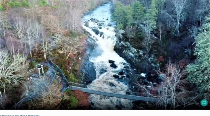
Road Trips In Scotland: ‘Inverness To Rogie Falls, Outer Hebrides’ (Video)
Today, we give ourselves a lift from the Lockdown Blues with a trip I did in November from my home in North Uist to Inverness, and back again via the Rogie Falls. The Rogie Falls are about 20 miles to the West of Inverness, and at certain times of the year you can see salmon leaping. No leaping salmon today though, just some enjoyable flying of my DJI Mavic Pro Drone (1st Generation.)
The contents of the video are: 00:00 – Introduction 01:02 – CalMac Ferry mv Hebrides Lochmaddy to Uig, then on to Inverness 03:15 – Inverness to the Rogie Falls 05:46 – The Rogie Falls 08:42 – Garve to Lochmaddy via Strathcarron and CalMac ferry from Uig 13:24 – Wrap up – He never smiles!

Aerial Views: ‘Steinway Tower’ – 111 West 57th Street In New York City
New York City has completed the world’s thinnest skyscraper, the 111 West 57th Street, which will soar above Central Park on Billionaire’s Row alongside the Central Park tower and other iconic supertall skyscrapers. 111 West 57th Street, also known as the Steinway Tower, is a supertall residential project by developers JDS Development Group and Property Markets Group in West Midtown in Manhattan, New York City. Located at 111 West 57th Street near Sixth Avenue, the development will be a combination of the original landmarked Steinway Building designed in 1925 by Warren & Wetmore, and a new tower addition on the adjacent site. Parkside Construction Builders is the general contractor. The world’s thinnest skyscraper will sway up to 5 feet during storms. The tower topped out in 2019 and is expected to open in early 2021. Steinway tower is one of the tallest buildings in the United States, as well as the thinnest skyscraper in the world with a width-to-height ratio of about 1:23.
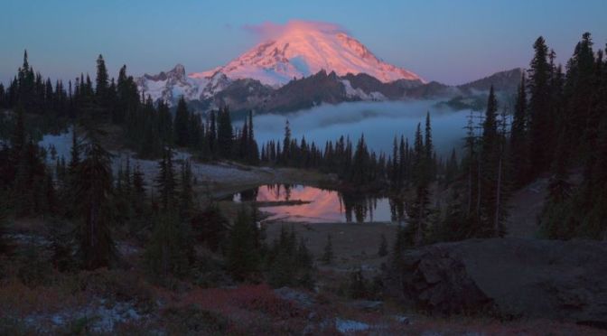
Aerial Views: Western U.S. And Southeast Asia (Video)
Filmed and Edited by: Jason Hatfield
This is the time of year myself and other photographers share our favorite photos from the past year. 2020 was obviously a very challenging time and despite struggles of my own I was vastly more fortunate than many. As I started to think on what were my favorite photographs I decided this time to share a film that conveys some of the incredible experiences and views I had. There’s so much more that happened but just these few minutes is enough.
Locations featured include: Colorado, Utah, Arizona, New Mexico, Wyoming, Oregon, Washington, Vietnam, Thailand, Myanmar, Indonesia
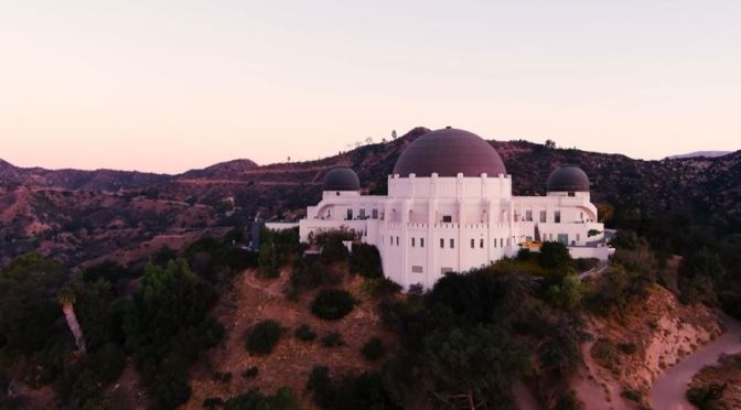
Aerial Views: Hollywood Sign, Griffith Observatory & Los Angeles Hills (Video)
Aerial footage of Hollywood Sign. Featuring: Hollywoodland, Griffith Observatory, Los Feliz and Hollywood Heights.
The Hollywood Sign is an American landmark and cultural icon overlooking Hollywood, Los Angeles, California. It is situated on Mount Lee, in the Hollywood Hills area of the Santa Monica Mountains.
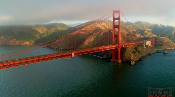
Views: The ‘Golden Gate Bridge’ In San Francisco, California (Video)
The Golden Gate Bridge stands at the entrance to California’s San Francisco Bay as a symbol of American ingenuity and resolve, having been constructed during the era of the Great Depression. Today, this beloved international icon and true engineering marvel carries about 40 million vehicles a year and serves not only as a vital transportation link but also as a major travel destination for millions of visitors from around the world.
Construction began on January 5, 1933. This was followed by the official ground breaking ceremony held on February 26, 1933, at nearby Crissy Field (now part of the Golden Gate National Recreation Area). The start of construction was met with great delight. A celebration at nearby Crissy Field went on for hours with at least 100,000 people in attendance. The San Francisco newspaper wrote the next day, “Two hundred and fifty carrier pigeons, provided by the San Francisco Racing Pigeon Club to carry the message of groundbreaking to every corner of California, were so frightened by the surging human mass that small boys had to crawl into their compartments in the bridge replica to shoo them out with sticks.”
Construction Timeline
December 22, 1932: Extending from Fort Baker pier, the construction of a 1,700 foot-long access road began to access the construction sites for the Marin anchorage, pier and tower.
January 5, 1933: Construction officially started.
January 1933 to February 1936: Marin and San Francisco anchorages and associated pylons.
January 1933 to May 1935: San Francisco anchorage.
January 1933 to June 1933: Marin pier.
January 1933 to June 1935: Marin anchorage.
February 1933: Work began on the east approach road from San Francisco that extended through the Presidio to the south end of the Golden Gate Bridge.
March 1933: Steel for the San Francisco and Marin towers that was prefabricated in Bethlehem steel foundries in Pottstown and Steelton, PA was brought by flatcar to Philadelphia and transferred to barges and shipped through the Panama Canal to Alameda, CA where it was stored until the Marin pier was completed and ready for tower erection.
March 1933 to March 1934: San Francisco tower access trestle was constructed extending 1100 feet offshore. Just as the trestle was completed, it was significantly damaged for the first time on August 14, 1933, when the McCormick Steamship Line’s Sidney M. Hauptman plowed through the thick fog and crashed into the access trestle, damaging about 400 feet. After repairs were made, on December 13, 1933, as a southwest gale battered the Golden Gate Strait for two days, the access trestle was again battered and this time there was 800 feet of wreckage. Trestle repairs began shortly thereafter and completed March 8, 1934.
November 7, 1933: Marin tower construction started. Depending on the source referenced, it was completed either on June 28, 1934 or sometime in November 1934.
October 24, 1934: San Francisco fender wall completed.
November 27, 1934: San Francisco pier area within the fender wall was un-watered.
January 3, 1935: San Francisco pier reached its final height of 44 feet above the water.
January 1935 to June 28, 1935: San Francisco tower construction.
August 2, 1935 to September 27, 1935: Harbor Tug and Barge Company strung the first wire cables to support the footwalks (aka catwalks) constructed across the Golden Gate Strait in preparation for main cable spinning.
October 1935 to May 1936: Main cable spinning and compression.
April 1936: Start of the Sausalito lateral approach road which was constructed as a W.P.A. project.
July 1936 to December 14, 1936: Suspended structure.
July 21, 1936: Start of San Francisco approach viaduct structures and Fort Point arch construction.
November 18, 1936: Two sections of the Bridge’s main span were joined in the middle. A brief ceremony marked the occasion when groups from San Francisco and Marin met and exchanged remarks at the center of the span. Major Thomas L. McKenna, Catholic Chaplin of Fort Scott, blessed the span while sprinkling holy water.
January 19, 1937 to April 19, 1937: Roadway completed.
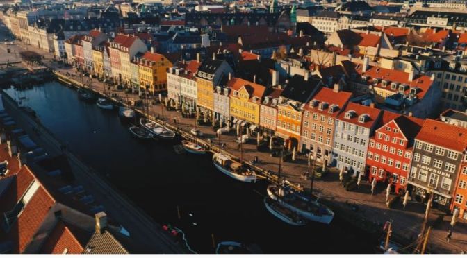
Aerial Views: ‘Copenhagen’ In Denmark’ (Video)
Denmark is a Scandinavian country comprising the Jutland Peninsula and numerous islands. It’s linked to nearby Sweden via the Öresund bridge. Copenhagen, its capital, is home to royal palaces and colorful Nyhavn harbor, plus the Tivoli amusement park and the iconic “Little Mermaid” statue. Odense is writer Hans Christian Andersen’s hometown, with a medieval core of cobbled streets and half-timbered houses.
Copenhagen, Denmark – Famed for Vikings and fairytales, Denmark’s capital city is starting to draw the crowds for entirely new and modern reasons. Copenhagen’s contemporary architecture, fluid, innovative design and Michelin-starred restaurants make this Scandinavian city a favourite with the European jet-set. International events like climate change conferences and cycling tours have placed this Danish city firmly on the global map.
Sights – One of the oldest amusement parks in the world, Tivoli Gardens comes into its own after the sun goes down and the fairy lights switch on. This rambling park offers flower gardens, boat rides, beer gardens, dreamy architecture, carnival rides and nightly firework displays. The park is a little bit kitsch, but a whole lot of fun, especially for travelers with children.
Explore the twisting, cobble-stoned medieval streets of Old Copenhagen and marvel at the architecture. If you want to know how the other half lives, take a tour of examples from royal Danish culture, including the Crown Jewels, at Rosenborg Slot, a17th century Renaissance castle located in the centre of the city. The castle was built by King Christian lV, and is surrounded by blooming gardens in the summer time.
For a dose of an alternative way of life, visit Christiania, Copenhagen’s commune of like-minded individuals who have their own law and lifestyle. Christiania is a sanctuary for pensioners, immigrants, artists, the homeless, the unemployed, students, intellectuals and musicians. Christiana is not governed by Copenhagen’s municipality, and there exists a liberal and progressive mindset within its borders. Christiana is relatively safe — there are rules within the community that forbid stealing, violence and firearms — but you should still go with a friend during the day.
