

Australia, officially the Commonwealth of Australia, is a sovereign country comprising the mainland of the Australian continent, the island of Tasmania, and numerous smaller islands. It is the largest country in Oceania and the world’s sixth-largest country.
Category Archives: Landscape

Aerial Views: Ireland (4K)
Ireland is an island in the North Atlantic. It is separated from Great Britain to its east by the North Channel, the Irish Sea, and St George’s Channel. Ireland is the second-largest island of the British Isles, the third-largest in Europe, and the twentieth-largest on Earth.
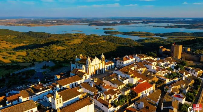
Aerial Views: The Cities & Landscapes Of Portugal
Portugal is a southern European country on the Iberian Peninsula, bordering Spain. Its location on the Atlantic Ocean has influenced many aspects of its culture: salt cod and grilled sardines are national dishes, the Algarve’s beaches are a major destination and much of the nation’s architecture dates to the 1500s–1800s, when Portugal had a powerful maritime empire.

Aerial Views: The Cities & Landscapes Of Tanzania
Tanzania is an East African country known for its vast wilderness areas. They include the plains of Serengeti National Park, a safari mecca populated by the “big five” game (elephant, lion, leopard, buffalo, rhino), and Kilimanjaro National Park, home to Africa’s highest mountain. Offshore lie the tropical islands of Zanzibar, with Arabic influences, and Mafia, with a marine park home to whale sharks and coral reefs.

Aerial Views: The Many Landscapes Of Iceland
Iceland, a Nordic island nation, is defined by its dramatic landscape with volcanoes, geysers, hot springs and lava fields. Massive glaciers are protected in Vatnajökull and Snæfellsjökull national parks. Most of the population lives in the capital, Reykjavik, which runs on geothermal power and is home to the National and Saga museums, tracing Iceland’s Viking history.

June 2021: Landscape Photography Magazine


Aerial Views: Cities And Islands Of Indonesia (4K)
Indonesia, officially the Republic of Indonesia, is a country in Southeast Asia and Oceania between the Indian and Pacific oceans. It consists of over seventeen thousand islands, including Sumatra, Java, Sulawesi, and parts of Borneo and New Guinea.

Timelapse Views: ‘Gros Morne National Park’ – Newfoundland, Canada
Gros Morne National Park is a unique place where everchanging weather and unique geology come together to create unexpected and captivating scenes. After many trips to this wonderful place, 2020 was the decisive year where I finally took the time to capture it’s varying moods through the medium of timelapses.
Gros Morne National Park is a Canadian national park and world heritage site located on the west coast of Newfoundland. At 1,805 km2 (697 sq mi), it is the second largest national park in Atlantic Canada after Torngat Mountains National Park, which has an area of 9,700 km2 (3,700 sq mi).
The park takes its name from Newfoundland’s second-highest mountain peak (at 806 m or 2,644 ft) located within the park. Its French meaning is “large mountain standing alone,” or more literally “great sombre.” Gros Morne is a member of the Long Range Mountains, an outlying range of the Appalachian Mountains, stretching the length of the island’s west coast. It is the eroded remnants of a mountain range formed 1.2 billion years ago. In 1987, the park was awarded World Heritage Site status by UNESCO because “The park provides a rare example of the process of continental drift, where deep ocean crust and the rocks of the earth’s mantle lie exposed.”[1]
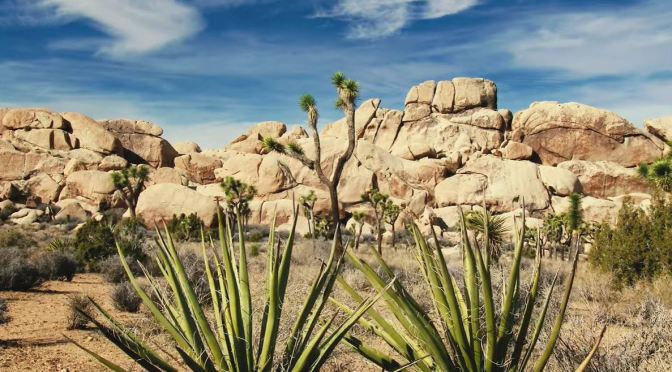
California Views: Joshua Tree National Park (4K)
Joshua Tree National Park is an American national park in southeastern California, east of Los Angeles and near Palm Springs. It is named after the Joshua trees (Yucca brevifolia) native to the Mojave Desert.
Originally declared a national monument in 1936, Joshua Tree was redesignated as a national park in 1994 when the U.S. Congress passed the California Desert Protection Act. Encompassing a total of 790,636 acres (1,235.4 sq mi; 3,199.6 km2) – slightly larger than the state of Rhode Island – the park includes 429,690 acres (671.4 sq mi; 1,738.9 km2) of designated wilderness.
Straddling San Bernardino and Riverside Counties, the park includes parts of two deserts, each an ecosystem whose characteristics are determined primarily by elevation: the higher Mojave Desert and the lower Colorado Desert. The Little San Bernardino Mountains traverse the southwest edge of the park.SHOW LESS
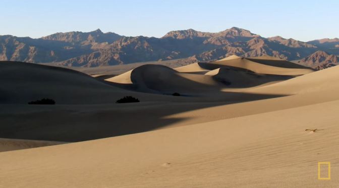
Desert Views: Death Valley Eastern California (Video)
Between Death Valley’s searing temperatures and the alpine air of Mount Whitney lies a 146-mile stretch that only the hardiest can survive.
Death Valley is a desert valley in Eastern California, in the northern Mojave Desert, bordering the Great Basin Desert. It is one of the hottest places on Earth, along with deserts in the Middle East and the Sahara.
