
0:15 AI can predict your risk of Parkinson’s – RETFound was trained using 1.6 million retinal images which gave it a picture of a healthy retina. Then its creators added images of eyes from people with certain conditions. Our eyes are a window to our health. They’re the only place where doctors can directly observe capillaries, our smallest blood vessels, enabling detection of cardiovascular illnesses such as hypertension. Eyes are also linked to the central nervous system, giving an insight into neural tissue, too. The RETFound tool was best at picking up eye diseases such as diabetic retinopathy. On Parkinson’s, stroke and heart disease, it performed not quite as well but still beat other AI models.
2:08 These are the most detailed heat maps of our planet – They use imagery from a satellite called HotSat-1 which can detect heat and cold at a resolution of 3.5 metres. The satellite can precisely map the fronts of forest fires, detect and monitor heat islands in cities and measure the thermal efficiency of buildings. This information can drive more effective decision-making.
3:51 AI designed this robot in 26 seconds – Researchers from Northwestern University gave an AI a simple prompt. ‘Design a robot that can walk across a flat surface’. By the 9th iteration, the AI had successfully met its brief. The robot could walk half its own body length per second. The entire iteration process took just 26 seconds and it ran on a laptop.
6:26 Norway completed it’s largest rewilding project – It’s centred around Sveagruva, a 100-year-old mining town on the Arctic island of Svalbard. Norway decided to close the town and its mining operations in 2017 and return the area to its natural state, restoring biodiversity and the local ecosystem.
_____________________________________________
The World Economic Forum is the International Organization for Public-Private Cooperation. The Forum engages the foremost political, business, cultural and other leaders of society to shape global, regional and industry agendas. We believe that progress happens by bringing together people from all walks of life who have the drive and the influence to make positive change.


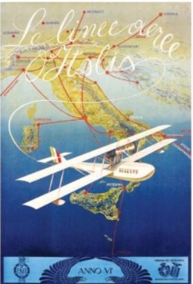 In this gorgeously illustrated collection of airline route maps, Mark Ovenden and Maxwell Roberts look to the skies and transport readers to another time. Hundreds of images span a century of passenger flight, from the rudimentary trajectory of routes to the most intricately detailed birds-eye views of the land to be flown over. Advertisements for the first scheduled commercial passenger flights featured only a few destinations, with stunning views of the countryside and graphics of biplanes. As aviation took off, speed and mileage were trumpeted on bold posters featuring busy routes. Major airlines produced highly stylized illustrations of their global presence, establishing now-classic brands. With trendy and forward-looking designs, cartographers celebrated the coming together of different cultures and made the earth look ever smaller.
