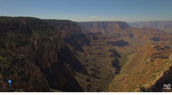
The Grand Canyon is a steep-sided canyon carved by the Colorado River in Arizona, United States. The Grand Canyon is 277 miles (446 km) long, up to 18 miles (29 km) wide and attains a depth of over a mile (6,093 feet or 1,857 meters).
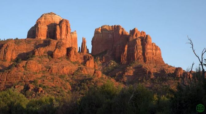
The main vortexes (places of spiritual energy) and some of the most scenic locations around the Red Rock Country, Sedona, Arizona.
Sedona is an Arizona desert town near Flagstaff that’s surrounded by red-rock buttes, steep canyon walls and pine forests. It’s noted for its mild climate and vibrant arts community. Uptown Sedona is dense with New Age shops, spas and art galleries. On the town’s outskirts, numerous trailheads access Red Rock State Park, which offers bird-watching, hiking and picnicking spots.
Locations in the video: Cathedral Rock (0:32), Bell Rock (0:01, 2:27), Chapel of the Holy Cross (3:00), Airport Mesa (3:35), Sedona & Tlaquepaque (4:04), Devil’s Bridge (5:06), Fay Canyon Arch (5:47), Boynton Canyon (6:18), West Fork of Oak Creek Canyon (7:54).
Brooklyn Bell, Chip Thomas, Shaun Martin and Nikki Cooley talk about their relationships with the people and incredible landscapes of the Arizona section of the Navajo Nation—the largest Tribal Nation in the U.S. at 27,425 square miles.
The Navajo Nation is a Native American indigenous tribe covering about 17,544,500 acres, occupying portions of northeastern Arizona, southeastern Utah, and northwestern New Mexico in the United States.
Moderna asks health regulators to authorize its covid-19 vaccine, Arizona, Wisconsin certify narrow victories for Joe Biden, and Louisville coffee shop customer pays it forward with random act of kindness.
Spent two days backpacking on the Hermit’s Rest Viewpoint to Tonto Trail to Bright Angel Trailhead in the Grand Canyon.
The dynamic interplay of soft and hard layers of stone created an open benchland at the rim of the Inner Gorge called the Tonto Platform. Easily visible from several South Rim overlooks, the greenish Tonto rocks have eroded into an obvious exception to the striking vertical cliffs that characterize most of Grand Canyon.
The Tonto Trail follows this natural trans-canyon route for 95 rough, unmaintained miles, from Red Canyon on the east to Garnet Canyon on the west. All of this makes the Tonto Trail unique among Grand Canyon pathways. Most descend from the rim towards the Colorado River, but the Tonto Trail offers passage by foot up and down the canyon, parallel to the course of the river. Because of its length, most hikers approach the Tonto Trail not as a single unit, but rather as a series of installments, breaking the route down into four or five sections defined by rim-to-river trails and the natural lay of the land.
A notable lack of reliable water makes most of the Tonto Trail a daunting, possibly dangerous, proposition, but the section between Bright Angel Trail and the Hermit Trail is blessed with three water sources hikers can count on. As a result, this segment of the Tonto Trail offers a degree of civility not found elsewhere along the trail, and it is here that most hikers get their first exposure to the unique nature of this singular trans-canyon route.
Joe Biden flips Arizona as Trump keeps transition in limbo, Chicago and Detroit told to hunker down as pandemic surges, and things to know about Friday the 13th.
Chiricahua National Monument is a “Wonderland of Rocks” located in Southeastern Arizona, USA. Stunning rock formations – pinnacles, hoodoos and balancing rocks – are the most common formations in the monument. Not many people visit this amazing area, since the monument is quite remote. Recorded October 2020
Trump, Biden locked in close election contest, Democrats flip Senate seat in Colorado, Republicans win in Alabama, and why can’t we vote from our smartphone.
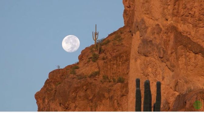
The Superstition Mountains is a range of mountains nearby Phoenix, Arizona. The Superstition Mountains are popular for their scenic hiking trails and with the legend of the Lost Dutchman’s Gold Mine. Apache believed an access to the underworld exists in the Superstition Mountains, and it is causing the dust storms in the Arizona desert. Recorded October 2020 in 4K Ultra HD with Sony AX700 and DJI Osmo Pocket.
Music: Suzanne Teng – Kingdom of Mountains – 3 – Kingdom of Mountains
R2 then became the second autonomous vehicle to receive a driverless testing permit in California. When the COVID-19 pandemic hit, we set up contactless delivery services with R2 at temporary care facilities in California to carry food, water, and medical supplies to patients and doctors with the goal of decreasing points of contagion.
Today, we’re excited to announce another first for Nuro. For the past few months, R2 has been testing on city streets fully autonomously in three different states. No drivers. No occupants. No chase cars.