

Richmond, the capital of Virginia, is among America’s oldest major cities. Patrick Henry, a U.S. Founding Father, famously declared “Give me liberty or give me death” at its St. John’s Church in 1775, leading to the Revolutionary War. The White House of the Confederacy, home of Confederate President Jefferson Davis during the Civil War, is now a museum in Court End, a neighborhood known for Federal-style mansions.
Tag Archives: Aerial Views
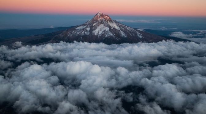
8K Views: Cities, Shores & Landscapes Of Oregon
Oregon, constituent state of the United States of America. Oregon is bounded to the north by Washington state, from which it receives the waters of the Columbia River; to the east by Idaho, more than half the border with which is formed by the winding Snake River and Hells Canyon; to the south by Nevada and California, with which Oregon shares its mountain and desert systems; and to the west by the Pacific Ocean, which produces the moderate climate of Oregon’s western lands. The capital is Salem, in the northwestern part of the state.
Video timeline: 0:00 Intro of oregon 0:40 Aerial view of smith rock 1:05 Oregon portland at sunset 1:27 Rocky mountain 1:32 Caruthers bridge in 1:40 Stream and mounta in portland 1:50 Newport oregon 2:04 Beautiful crater lake 2:13 Mt hood & mountain 2:19 Oregon portland at night 2:31 Crater lake with snowy mountain 2:39 Ocean with wave 2:48 Aerial ocean 2:53 Aerial oregon and snowy mountain 3:08 Green fields with lake 3:15 Natural landscape 3:29 Golf course 3:38 Lake view at sunset time 3:47 Oregon eugene 3:57 Covered bridge 4:01 Oregon lake 4:29 Aerial oregon 4:29 Sunset and sonwy mountain 4:42 Oregon field 4:47 Oregon eugene 5:03 Oregon waterfall 5:16 Smith rock aerial view 5:46 Rocky shoreline 5:58 Mt bachelor 6:15 Snowy mountains 6:20 Portland at sunset 6:49 Mountain 6:56 Skyscraper in oregon 7:26 Mountain and field 7:36 Skyscraper in oregon, USA 8:00 Waldport oregon 8:08 Colorful sunset 8:12 Aerial view mountain 8:20 Canon beach 8:45 Crater lake 8:56 Canon beach 9:26 Beach oregon 9:38 Crater lake 10:01 Deschutes river 10:31 Mt hood 10:46 Paddle board 10:54 Oregon eugene 11:23 Oregon clear lake 11:56 Mountainside 12:01 Rocky ocean 12:14 Mt bachelor 12:32 Aerial view of portland, USA 12:44 Snowy oregon 13:03 Lake of oregon 13:24 Waterfall in oregon 13:38 Smith rock 14:07 Mount hood 14:27 Painted hills 14:42 Mt bachelor 14:59 Relaxing river & rock 15:09 Oregon mt bachelor 15:30 Oregon rocky hill 15:50 Oregon portland 16:12 Oregon smith rock 16:42 Oregon skyscraper 17:12 Downtown in Oregon 17:42 Aerial Oregon 18:09 Smith rock 18:29 Aerial skyscraper
Admitted to the union as the 33rd state on February 14, 1859, Oregon comprises an area of startling physical diversity, from the moist rainforests, mountains, and fertile valleys of its western third to the naturally arid and climatically harsh eastern deserts.
Mountains, plateaus, plains, and valleys of different geologic ages and materials are arrayed in countless combinations, including such natural wonders as the Columbia River Gorge, Oregon Caves National Monument, Crater Lake National Park, the majestic snow-covered peaks of the Cascade Range, and the central Oregon “moon country” (lava fields that served as a training site for astronauts in the U.S. space program in the 1960s). The name Oregon is thought to be Native American in origin.
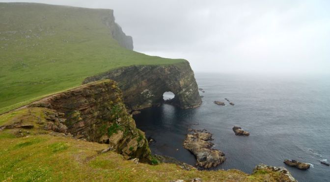
Aerial Views: Coastlines & Landscapes Of Scotland
Scotland, most northerly of the four parts of the United Kingdom, occupying about one-third of the island of Great Britain. The name Scotland derives from the Latin Scotia, land of the Scots, a Celtic people from Ireland who settled on the west coast of Great Britain about the 5th century CE. The name Caledonia has often been applied to Scotland, especially in poetry. It is derived from Caledonii, the Roman name of a tribe in the northern part of what is now Scotland.
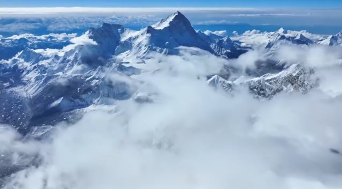
Photography: Stunning Views Of Mount Everest
Never seen before images of the detailed Everest Summit, C1, C2, C3 and C4. The Khumbu Icefall to the Western Cwm, all captured in stunning detail by the DJI Mavic 3.
Mount Everest is Earth’s highest mountain above sea level, located in the Mahalangur Himal sub-range of the Himalayas. The China–Nepal border runs across its summit point. Its elevation of 8,848.86 m was most recently established in 2020 by the Chinese and Nepali authorities.
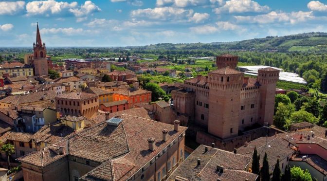
Views: Castles Of Modena In Emilia-Romagna, Italy
Modena and the surrounding area is extremely rich in historic and cultural treasures like these. In their unparalleled beauty, within each castle’s walls lies a special story.
The castles of the Modena area date to a range of historical periods but together make up an invaluable legacy. They remain today—just as they were when they were built—important cultural landmarks for local community residents.
- First stop – Palazzo Pio Carpi – Palazzo Pio in Carpi is an imposing and complex structure that comprises fortifications, towers, courtyards, and buildings constructed between the fourteenth and seventeenth centuries. The Palazzo looks out onto Piazza dei Martiri, one of Italy’s most beautiful piazzas, to breathtaking effect. Starting in 1300 and for most of the following two centuries, Palazzo Pio was the residence of the Pio family. The Pio Prince Alberto III, nephew of the famous Pico della Mirandola, transformed the fortress into a splendid Renaissance palace whose rooms were decorated with frescoes by court painters.Today, the town of Carpi has adapted the palazzo for use as a world-class cultural center that houses the Palazzo Pio Museum; the Municipal Museum; the Castello dei Ragazzi, a children’s art and recreation center; and the fascinating Museum and Monument to Political and Racial Deportees.
- Second stop – Calcagnini Fortress Formigine – The ravishing Rocca Calcagnini Fortress stands in the heart of Formigine, a symbol of the local community and a center for collective historical memories. Built in 1201 by the city of Modena as a defense against attacks by the rival city of Reggio Emilia and to secure its control of the territory, beginning in 1300 the Rocca Calcagnini Fortress was passed among various local noble families until it became property of the Pio family of Carpi, the Estes, and finally the Calcagninis.Around 1400, when the fortress was under the control of the Pios, it was turned into a castle-residence that appears today much as it did then, with a marquis’s palazzo and grounds encircled by a wall with four corner towers and a guardhouse.During the Second World War, the fortress was irreparably damaged in a ferocious bombardment in which virtually the entire Calcagnini family was lost. In 1946, it became the property of the town government and was rebuilt and transformed for use as the city hall.Today the castle houses municipal offices on its ground floor (the city council chambers and a venue for wedding ceremonies) with reception halls located in the northeast tower.To make your visit to the Rocca Calcagnini Fortress extra special, don’t miss the Multimedia Museum of Archaeology. Beautiful and innovative multimedia displays tell the story of the fortress and of the Calcagnini nobility.The Calcagnini Fortress is Formigine’s sparkling “living room.” In addition to housing a restaurant and a wine cellar, each year the castle hosts events of all kinds—music, theater, and much more.
- Third stop – Spezzano Castle Fiorano Modenese – The origins of Spezzano Castle date to the Middle Ages. The castle was transformed into a noble family residence by the Pios of Savoia in 1529.Today, Spezzano Castle is an elegant country residence surrounded by grounds landscaped in the 19th-century—a lovely place to relax or perhaps have lunch in one of the designated picnic areas.The splendid porticoed courtyard dates to the Renaissance, and the Sala delle Vedute, with its splendid frescoes of towns, towers, and castles of Sassuolo’s feudal period, is especially striking.Its pentagonal tower, at one time a prison, today houses the Municipal Vinegar Cellar and the Fiorano Museum of Ceramics, dedicated to the local history of ceramics, one of the area’s most admired products.
- Fourth stop – Vignola Fortress Vignola – The Vignola Fortress has also become a symbol—in this case, of Italy’s cherry capital. Its towers, drawbridge, and moat provide one of the most fascinating examples of defensive architecture in the entire Emilia-Romagna Region.The Vignola Fortress was built in the eighth century by the abbot of Nonantola to defend the abbey’s lands. After passing through the hands of several noble families, in 1401 it was ceded by the Este family of Ferrara to Uguccione Contrari who transformed it into a sumptuous noble home and filled the residence with frescoes and precious objets d’art.Vignola’s picturesque city center provides the perfect setting for the imposing and well-preserved Vignola Fortress. The four-sided structure contains five floors and has three square towers. The internal courtyard is magnificent and, on the left side, the “Rocchetta” (the “little fortress”) and the Contrari and Grassoni halls are located. One of the most beautiful structures is the frescoed chapel, a rare gem of “International Gothic” style.
- Fifth stop – Montecuccoli Castle in Pavullo Pavullo nel – FrignanoMontecuccoli Castle is perched on a spur of rock that overlooks the Scoltenna-Panaro River Valley, three kilometers from the center of Pavullo in the heart of the Frignano area.After briefly being governed by Modena, the surrounding area was ruled by the Montecuccoli family, the powerful lords of Frignano, until the arrival of the House of Este in the mid-fourteenth century. In these ancient times, the Montecuccoli Castle was the residence and military center of the Montecuccoli family, who built dozens of attached towers and fortresses to keep watch over the roads to Tuscany. At the highest point of this point of rock is the original castle keep, which is surrounded by other structures and three rings of walls, constructed over time.Below the castle and through a Gothic portal lies a beautiful medieval village, where the Palazzo del Podestà and the fifteenth-century Church of San Lorenzo are especially noteworthy.Starting in the 1960s, the castle became the property of the town, which restored it and built the Montecuccoli Museum Complex. The Complex contains the Frignano Botanical Museum; Raffaele Biolchini’s “Donazione,” a sculpture gallery featuring works in marble, wood, terracotta, and other materials by one of Modena’s preeminent modern sculptors; and Gino Covili’s “Paese Ritrovato,” a cycle of paintings and drawings dedicated to the work, lives, and history of the people of Frignagno.

Aerial Views: Curieuse Island In The Seychelles
Curieuse Island is a small granitic island 1.13 sq mi in the Seychelles close to the north coast of the island of Praslin. Curieuse is notable for its bare red earth intermingled with the unique coco de mer palms, one of the cultural icons of the Seychelles, only growing on the two neighboring islands.
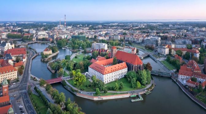
8K Views: The Landmarks & Landscapes Of Poland
Poland, country of central Europe. Poland is located at a geographic crossroads that links the forested lands of northwestern Europe to the sea lanes of the Atlantic Ocean and the fertile plains of the Eurasian frontier.
Video timeline: 0:00 intro 0:15 Green field in Sułoszowa 0:23 Wooden house cover by the ice 0:34 Tatra mountains 0:40 Odra river 0:45 Krakow Traffic 0:50 Warsaw at night 1:29 Castle ruins 1:33 Rocky mountain 1:43 Field in Sułoszowa 1:51 Stare miasto 2:02 Castle ruins 2:13 Krzyżtopór Castle 2:23 Turbines 2:30 Warsaw at night 2:44 Castle ruins 2:58 Pieskowa skala 3:06 Wawel castle 2:14 Green mountain 3:18 Old castle 3:28 warsaw time-lapse 3:33 Culture and Science 3:44 Nowy castle 3:53 Krakow 4:08 Poland warsaw 4:34 Odra river 4:51 Night warsaw 4:55 Tatra mountain 5:04 Zakopane 5:15 Turbine 5:26 Kazimierz Dolny 5:36 Old castle 5:46 Clock Tower 5:56 Wawel royal castle 6:06 Renaissance castle 6:17 Stare miasto 6:27 Stare miasto 6:43 Capital of poland 6:55 Modern downtown 7:05 Clock Tower 7:17 Krakow 7:27 Krakow 7:37 Aerial View 7:47 Skyscrapers 7:58 Clock Tower 8:07 Turbine 8:19 Nowy wisnicz 8:29 Castle 8:40 Wroclaw 8:52 Poland at night 9:13 Royal castle 9:32 Clock Tower 9:52 Skyscraper 10:04 Clock Tower
Now bounded by seven nations, Poland has waxed and waned over the centuries, buffeted by the forces of regional history. In the early Middle Ages, Poland’s small principalities and townships were subjugated by successive waves of invaders, from Germans and Balts to Mongols.
In the mid-1500s, united Poland was the largest state in Europe and perhaps the continent’s most powerful nation. Yet two and a half centuries later, during the Partitions of Poland (1772–1918), it disappeared, parceled out among the contending empires of Russia, Prussia, and Austria.
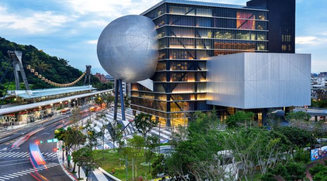
Views: Taipei Performing Arts Center In Taiwan
Viewers can explore the interiors of the newly-opened Taipei Performing Arts Center by Dutch studio OMA in this drone video, produced by Shephotoerd Co. Photography.
Opened to the public on 7 August, the Taipei Performing Arts Center is a 59,000-square-metre cultural venue in Taiwan that incorporates three unique theatres.
Read more on Dezeen: https://www.dezeen.com/?p=1829625

Travel Views: Dublin In Eastern Ireland (4K)
Dublin, capital of the Republic of Ireland, is on Ireland’s east coast at the mouth of the River Liffey. Its historic buildings include Dublin Castle, dating to the 13th century, and imposing St Patrick’s Cathedral, founded in 1191. City parks include landscaped St Stephen’s Green and huge Phoenix Park, containing Dublin Zoo. The National Museum of Ireland explores Irish heritage and culture.
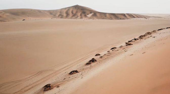
Aerial Views: Namib Desert In Southern Africa (4K)
The Namib is a coastal desert in Southern Africa. The name Namib is of Khoekhoegowab origin and means “vast place”. According to the broadest definition, the Namib stretches for more than 2,000 kilometres (1,200 mi) along the Atlantic coasts of Angola, Namibia, and South Africa, extending southward from the Carunjamba River in Angola, through Namibia and to the Olifants River in Western Cape, South Africa.[2][3][4] The Namib’s northernmost portion, which extends 450 kilometres (280 mi) from the Angola-Namibia border, is known as Moçâmedes Desert, while its southern portion approaches the neighboring Kalahari Desert. From the Atlantic coast eastward, the Namib gradually ascends in elevation, reaching up to 200 kilometres (120 mi) inland to the foot of the Great Escarpment.[2]
