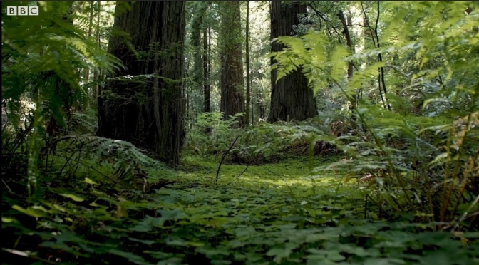
Category Archives: Wilderness

Sweden Views: A Hike To Ristafallet Waterfall (4K)

50 meters wide with a height of 14 meters. Ristafallet is one of Sweden’s most beautiful waterfalls, and famous from the movie “Ronia the Robber’s Daughter”.

In Hålland between Undersåker and Järpen lies the easily accessible Ristafallet. Turn off the E14 from Hålland into Ristafallet’s Camping. Park by the restaurant, then walk through the camping area until you find the waterfall.

Aerial Short Films: ‘Mountains Song’

Mountains Song – is my latest short drone film. In this film the main subject are mountains of all sizes tall and short, with clouds and fog as a complimentary. I also wanted to experiment a bit with a post production and grading. I was inspired by Ansel Adams black and white contrasty landscape photos and wanted to create similar imagery, but with in a video. To my big surprise I found almost no b&w drone films, so I wanted to fix tat.

The subdued atmospheric sound from Ryan Taubet in my opinion compliments the airy scenery.

Filmed and Edited by: Vadim Sherbakov

Woodland Views: North York Moors In England

The North York Moors is an upland area in north-eastern Yorkshire, England. It contains one of the largest expanses of heather moorland in the United Kingdom. The area was designated as a National Park in 1952, through the National Parks and Access to the Countryside Act 1949.

Woodland Sanctuary is a joint exhibition between myself and Joe Cornish. The work was gathered over the last 6 years, all of it within the North York Moors National Park. Using my archived footage, I’ve made this relaxing video of local woodland scenes which will play on a loop in the Sanctuary room of the exhibition. I’ve decided to share it online so that it can be enjoyed by all.

The exhibition consists of 9 themes which reflect the preoccupations and imaginative journeys of the photographers during their time in the woods. The images reflect the intense experience of studying trees in all weather conditions and all times of year.

Website

Nature: ‘The Glen Beyond’ – A Canoe Journey Into The Scottish Highlands

In February 2022, the British Isles were hit by three consecutive storms, some of the strongest seen in decades. In the days before the storms arrived, we decided to change the plan for our canoeing expedition whilst we were already on our way to Scotland. Instead of paddling the exposed lochs along the west coast, we opted for a more sheltered location. A glen tucked away right in the heart of the highlands. This film showcases the highlights of our journey.

Read the full article written by Ian Finch here: https://www.sidetracked.com/the-glen-…

Timelapse Views: Canyons & Colors Of Moab, Utah

Filmed and Edited by: Ron Risman

This is Moab is a film that was designed to highlight the wide variety of landscapes that you can experience when you visit Moab, Utah – and most of these locations are not located in Arches or Canyonlands National Parks.

Moab Utah is a many things to many people, but what ever it is that brings you to Moab (vacation, off-roading, rock climbing, biking, hiking, photography, painting, rafting, camping) you may not realize that if you just visit the two national parks (Arches and Canyonlands) you’re missing out on 98% of what Moab has to offer.

The Bureau of Land Management (BLM) in Moab manages over 1.8 MILLION acres of breathtaking red rock canyons, cliffs, fins, spires and hoodoos – and all of this public land is located outside of the National Parks.

Then there’s the LaSal Mountains, the second largest in all of Utah – with elevations reaching 13,000 feet. Tired of the 100 degree desert heat? Take a drive on the LaSal Mountain Loop Rd and enjoy cooler weather and spectacular mountain scenery.

Moab, Utah is one of the most amazing locations you can visit – whether you’re seeking adventure, solitude, or anything in between. If you’re a painter, photographer, hiker, biker, rock climber, rafter, off-roader, or traveling in an RV or camper – Moab has what you’re looking for. As a photographer Moab offers some of the finest landscapes anywhere on earth – with millions of acres of red-rock sandstone arches, spires, fins, canyons, and hoodoos.

Moab is also home to the second tallest mountain range in Utah – the La Sal Mountains with peaks reaching over 13,000 feet in elevation. Often these peaks are snow-capped even in the spring and early Summer – making for a beautiful contrast between desert landscape and mountains. In summer take a short 1 hour drive from the desert climate of Moab with temperatures near 100 degrees to sitting under an Aspen grove on the La Sal mountains with temperatures in the mid 70’s.

Love stargazing? You’ll love the dark skies around Moab. Head into Arches National Park, Canyonlands National Park, or Dead Horse Point State Park and enjoy some of the darkest skies in the country. The International Dark Sky Association has designated these locations as dark-sky parks, and you’ll soon discover why. But don’t stop there – anytime you leave town, you’ll discover that the lack of any significant light pollution and the dry high-desert climate ensures a wonderful view of the night sky on most nights. You’ll also be happy to know that Moab is also one of the safest places to hang outdoors – as there really isn’t much in the way of predatory wildlife.

Forest Views: Khao Jom Pa Mangroves, Thailand (4K)

Trang, also called Mueang Thap Thiang, is one of the southern provinces (changwat) of Thailand, on the west side of the Malay Peninsula facing the Strait of Malacca. Neighboring provinces are (from north clockwise) Krabi, Nakhon Si Thammarat, Phatthalung, and Satun.

Trang was formerly a port involved in foreign trade. It was the first place where rubber was planted in Thailand. Phraya Ratsadanupradit Mahison Phakdi brought rubber saplings from Malaya and planted them here in 1899, and rubber is now an important export of the country. The Trang River flows through the province from its origin in the Khao Luang mountain range, and the Palian River flows from the Banthat mountains. The province of Trang has an area of approximately 5,000 square km and 199 km of Strait of Malacca shoreline.

Top Hikes: California’s Condor Trail (400 Miles)

The rugged chaparral of California’s Sespe Wilderness lay hidden under the camouflage of mahogany and sage hues. Nearly a week into her thru-hike on the Condor Trail, Brittany Nielsen surveyed this scraggly landscape. She had already faced a downpour, severe flooding, and hypothermia. Now, she leaned against her pack in the spring sun, scanning the thickets and hoping the trail would emerge like a scrub jay.

“I learned a lesson about being calm while being lost on the trail,” Nielsen says. Earlier, behind on miles and low on her food supply, she had searched for the path in a frenzy, only to find herself exhausted. The trail on the side of Sespe Creek was fiercely overgrown in sections and required strong orienteering skills to navigate.

“When I opened my eyes I was looking at the sky,” Nielsen says, “And up above me—I couldn’t believe it—there was a condor.” She noted the telltale band of white feathers in the shape of a scalene triangle that decorated the bird’s nine-foot wingspan. When the condor drifted out of sight, Nielsen dropped her gaze into the chaparral where, directly in front of her, she discovered a small rock cairn that marked the trail.

Over the course of her 37 days on the hike, Nielsen would lose and gain the trail numerous times as she fought through menacing brush and screamed expletives that no one could hear in the most remote pockets of Los Padres National Forest. She would travel through seven wilderness areas, along the shores of central California, past colonies of elephant seals, and across the ancestral lands of the ChumashSalinanEsselenTataviam, and Costanoan peoples.

SOURCES: BRYAN CONANT; IUCN REDLIST

Unlike California’s well-established John Muir and Pacific Crest Trails, the Condor Trail is a thru-hiking “route,” meaning its course exists—as a continuous thread of trails and roads and cross-country travel—but that it lacks proper signage and maintenance. While these popular thru-hiking routes receive hundreds of hikers a year, Nielsen took on the Condor Trail alone in 2015. When she finished on June 18th, she was the first thru-hiker to complete it.

Aerial Views: Landscapes And Coastlines In Oregon

Oregon is a state in the Pacific Northwest region of the Western United States. The Columbia River delineates much of Oregon’s northern boundary with Washington, while the Snake River delineates much of its eastern boundary with Idaho. The 42° north parallel delineates the southern boundary with California and Nevada.