

Brazil, officially the Federative Republic of Brazil, is the largest country in both South America and Latin America. At 8.5 million square kilometers and with over 211 million people, Brazil is the world’s fifth-largest country by area and the sixth most populous.
Tag Archives: Landscapes
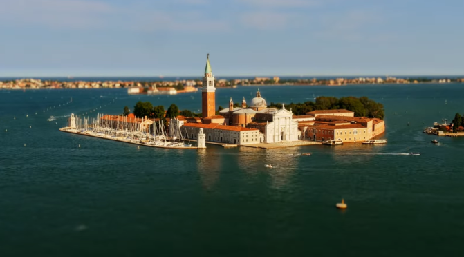
Tilt-Shift Views: Cities & Landscapes Of Europe (4K)
This is a short compliation with some of the best shots from all Little Big World episodes that were released in 2021. Pandemic-wise there are mostly episodes from Europe except for the Los Angeles film, which was shot pre-pandemic.
Chapters 00:00 Ore Mountains, Germany 00:21 Hallstatt, Austria 00:31 Moldova 00:47 Venice, Italy 01:02 Danube Delta Romania 01:10 Romania 01:33 Sofia, Bulgaria 01:45 Los Angeles, USA 01:55 Garmisch-Partenkirchen, Germany
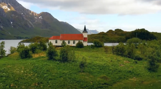
Views: Landscapes Of The Nordic Countries (4K)
The Nordics are one of the most magical regions in the world! Nordic Landscapes Timelapse | Amazing Landscapes.
The Nordic countries are a geographical and cultural region in Northern Europe and the North Atlantic. It includes the sovereign states of Denmark, Finland, Iceland, Norway and Sweden as well as the autonomous territories of the Faroe Islands and Greenland, and the autonomous region of Åland.
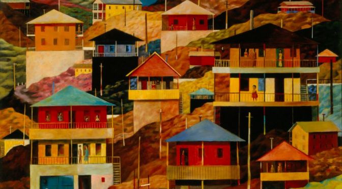
Exhibits: ‘Philip C. Curtis – Landscapes of Arizona’ (Phoenix Art Museum)
Philip C. Curtis saw the desert through a lens of magic realism.
Landscape remains one of the most popular subjects for artists visiting and residing in Arizona. Philip C. Curtis, while not known as a landscape painter, draws extensively on that subject. Curtis came to the state in 1937 to establish the Phoenix Federal Art Center under the Federal Art Project, a New Deal program. He left two years later to head a similar facility in Des Moines, Iowa, but returned to Arizona in 1947.
Settling in Scottsdale, he painted surreal compositions, with figures in Victorian costumes set in the desert. Arizona’s landscapes were a rich source of inspiration for him, and while his canvases do not portray any recognizable geological features, his work may be contextualized within the work of a broad spectrum of artists who came to the state. Curtis saw the desert through a lens of magic realism. This differed from Maxfield Parrish, Eugene Berman, and other artists who preferred more representational modes.

Views: Winter Landscapes From Around The World

Views: San Felipe Creek In Southwestern Texas
Fly above San Felipe Creek and the Rio Grande at the golden hour before sunset.
The Rio Grande, known in Mexico as the Río Bravo del Norte and as the Río Bravo, is one of the principal rivers in the southwestern United States and in northern Mexico. The length of the Rio Grande is 1,896 miles and originates in south-central Colorado, in the United States, and flows to the Gulf of Mexico.

Aerial Views: Landscapes And Cities Of Spain (4K)
Spain, a country on Europe’s Iberian Peninsula, includes 17 autonomous regions with diverse geography and cultures. Capital city Madrid is home to the Royal Palace and Prado museum, housing works by European masters. Segovia has a medieval castle (the Alcázar) and an intact Roman aqueduct. Catalonia’s capital, Barcelona, is defined by Antoni Gaudí’s whimsical modernist landmarks like the Sagrada Família church.
Aerial Views: Kamchatka Peninsula, Eastern Russia
Kamchatka Peninsula, also spelled Kamčatka, Russian Poluostrov Kamchatka, peninsula in far eastern Russia, lying between the Sea of Okhotsk on the west and the Pacific Ocean and Bering Sea on the east. It is about 750 miles (1,200 km) long north-south and about 300 miles (480 km) across at its widest; its area is approximately 140,000 square miles (370,000 square km).
Two mountain ranges, the Sredinny (“Central”) and Vostochny (“Eastern”), extend along the peninsula and rise to 15,584 feet (4,750 metres) in Klyuchevskaya Volcano. The trough between these mountain chains is occupied for much of its length by the Kamchatka River. Of the 127 volcanoes, 22 are still active, as are a number of geysers and hot springs. Most of the active volcanoes lie along a fault line on the eastern flank of the Vostochny Range.
The western coastlands of the Kamchatka Peninsula form a low plain crossed by many rivers and with extensive swamps, while the eastern coast is an alternation of broad gulfs and cliffed, mountainous peninsulas. A small geothermal-power station uses underground steam and is in operation near the southern end of the peninsula.
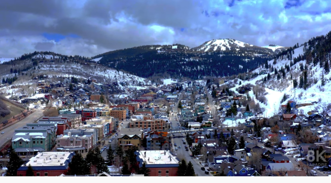
Utah Views: Landscapes, Landmarks & Cities (8K)
Utah is a state in the Mountain West subregion of the Western United States. Utah is a landlocked U.S. state bordered to its east by Colorado, to its northeast by Wyoming, to its north by Idaho, to its south by Arizona, and to its west by Nevada. Utah also touches a corner of New Mexico in the southeast.
Video timeline: 0:00 1. Salt Lake City skyline at sunset with mountains behind 0:08 2. Park City Mountain Resort, Utah 0:16 3. Utah mountain landscape 0:22 4. Park City Mountain Resort 0:30 5. Horses at Zion National Park 0:38 6. Road through the desert and mountains of Utah 0:47 7. Amazing rock formations in Utah 0:56 8. Salt Lake City at night 1:03 9. Amazing rock formations in Utah 1:11 10. Utah Arches National Park on a sunny day 1:18 11. Stormy desert buttes and river near Moab, Utah 1:26 12. Butte landscape, Utah 1:34 13. Salt Lake City, Utah 1:40 14. Pink cliffs in Snow Canyon State Park, Utah 1:49 15. Salt Lake City capital building 1:57 16. Stunning red sandstone hoodoos in Bryce Canyon National Park 2:07 17. Colorado river highway 128, Utah 2:18 18. Salt Lake City skyline and cathedral 2:29 19. The Mars Desert Research Station (MDRS) in Utah 2:36 20. Colorado river highway 128, Utah 2:46 21. Sunny dry desert towards big rocky mountains and clear blue sky in Utah 2:55 22. Salt Lake City capitol building city skyline 3:03 23. Peaceful reflective water between canyons in Lake Powell 3:13 24. Salt Lake City Assembly Hall from Latter-day Saints 3:23 25. Mountain landscape in Utah 3:42 26. Cliff edge in Southern Utah 3:48 27. Utah Arches National Park at sunrise 3:58 28. Lake Powell rock formations and canyon walls 4:10 29. Salt Lake City skyline at sunset with mountains 4:20 30. Butte factory in Utah 4:30 31. Mexican Hat rock formation in Utah 4:41 32. Red Rock Mesa mountain cliffs in Red Rock desert, Utah 4:48 33. Utah Arches National Park on a sunny day 5:02 34. Lake Powell with canyons in the background 5:13 35. Salt Lake City capitol building 5:25 36. The Mars Desert Research Station (MDRS) in Utah 5:34 37. Utah mountain landscape 5:50 38. Winding road leading to unique Bears Ears, Utah 6:01 39. Rock formations in Paria, Utah 6:12 40. Texas Gulf Potash Pond One in Utah 6:28 41. Juniper trees in a vast desert in Central Utah 6:35 42. Red rock buttes and cliffs in Utah 6:49 43. Colorado river in the desert, Utah 7:04 44. Salt Lake City, Utah 7:27 45. Road in beautiful desert, Burr Trail canyon 7:33 46. Antelope Island, Utah 7:47 47. Empty desert road at sunrise in Monument Valley, Utah 7:59 48. Stunning red sandstone hoodoos in Bryce Canyon National Park 8:14 49. Utah Arches National Park on a sunny day 8:20 50. The Mars Desert Research Station (MDRS) in Utah 8:34 51. Utah Arches National Park at sunrise 8:41 52. Texas Gulf Potash Pond One in Utah 8:58 53. Utah Arches National Park at sunrise 9:06 54. Grand Canyon at Utah border 9:20 55. Rock formations in Paria, Utah 9:39 56. Famous sunny American desert highway road in Monuments Valley 9:53 57. Salt Lake City, Utah

Coastal Views: Calanques National Park In France
Between the southern French cities of Marseille and La Ciotat lies a magnificent coastline with 40 kilometres of cliffs and coves. The landscapes of the Calanques National Park are breathtaking. To safeguard this fragile natural heritage and rescue amateur mountaineers who get into difficulty, wardens and firefighters are constantly on a war footing. FRANCE 24 went to meet them.
