
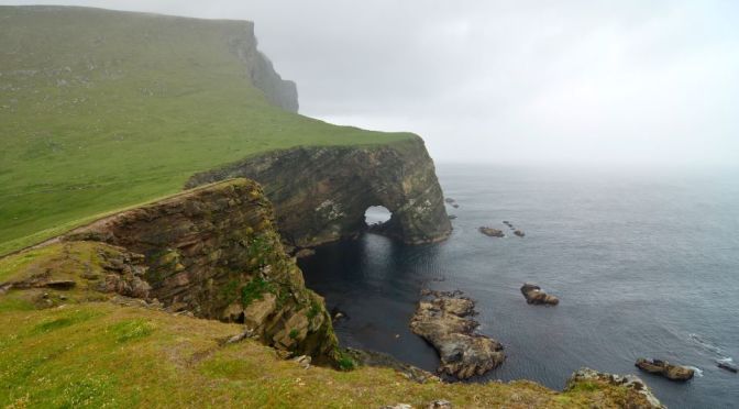
Scotland, most northerly of the four parts of the United Kingdom, occupying about one-third of the island of Great Britain. The name Scotland derives from the Latin Scotia, land of the Scots, a Celtic people from Ireland who settled on the west coast of Great Britain about the 5th century CE. The name Caledonia has often been applied to Scotland, especially in poetry. It is derived from Caledonii, the Roman name of a tribe in the northern part of what is now Scotland.
Category Archives: Landscape
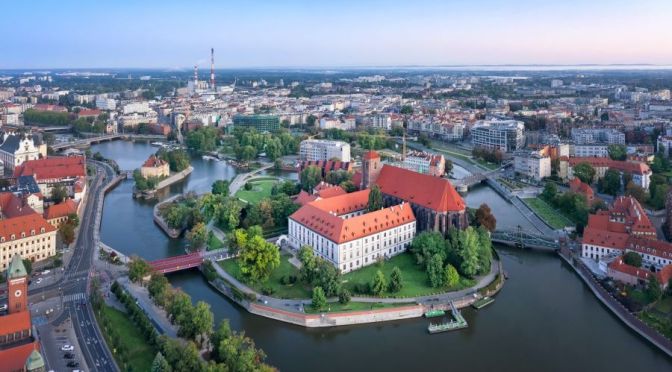
8K Views: The Landmarks & Landscapes Of Poland
Poland, country of central Europe. Poland is located at a geographic crossroads that links the forested lands of northwestern Europe to the sea lanes of the Atlantic Ocean and the fertile plains of the Eurasian frontier.
Video timeline: 0:00 intro 0:15 Green field in Sułoszowa 0:23 Wooden house cover by the ice 0:34 Tatra mountains 0:40 Odra river 0:45 Krakow Traffic 0:50 Warsaw at night 1:29 Castle ruins 1:33 Rocky mountain 1:43 Field in Sułoszowa 1:51 Stare miasto 2:02 Castle ruins 2:13 Krzyżtopór Castle 2:23 Turbines 2:30 Warsaw at night 2:44 Castle ruins 2:58 Pieskowa skala 3:06 Wawel castle 2:14 Green mountain 3:18 Old castle 3:28 warsaw time-lapse 3:33 Culture and Science 3:44 Nowy castle 3:53 Krakow 4:08 Poland warsaw 4:34 Odra river 4:51 Night warsaw 4:55 Tatra mountain 5:04 Zakopane 5:15 Turbine 5:26 Kazimierz Dolny 5:36 Old castle 5:46 Clock Tower 5:56 Wawel royal castle 6:06 Renaissance castle 6:17 Stare miasto 6:27 Stare miasto 6:43 Capital of poland 6:55 Modern downtown 7:05 Clock Tower 7:17 Krakow 7:27 Krakow 7:37 Aerial View 7:47 Skyscrapers 7:58 Clock Tower 8:07 Turbine 8:19 Nowy wisnicz 8:29 Castle 8:40 Wroclaw 8:52 Poland at night 9:13 Royal castle 9:32 Clock Tower 9:52 Skyscraper 10:04 Clock Tower
Now bounded by seven nations, Poland has waxed and waned over the centuries, buffeted by the forces of regional history. In the early Middle Ages, Poland’s small principalities and townships were subjugated by successive waves of invaders, from Germans and Balts to Mongols.
In the mid-1500s, united Poland was the largest state in Europe and perhaps the continent’s most powerful nation. Yet two and a half centuries later, during the Partitions of Poland (1772–1918), it disappeared, parceled out among the contending empires of Russia, Prussia, and Austria.

Timelapse Views: Cities & Landscapes Of Taiwan (8K)
Taiwan, officially the Republic of China (ROC),is a country in East Asia, at the junction of the East and South China Seas in the northwestern Pacific Ocean, with the People’s Republic of China (PRC) to the northwest, Japan to the northeast, and the Philippines to the south. The territories controlled by the ROC consist of 168 islands,[j] with a combined area of 36,193 square kilometres (13,974 sq mi).[15][33] The main island of Taiwan, also known as Formosa, has an area of 35,808 square kilometres (13,826 sq mi), with mountain ranges dominating the eastern two-thirds and plains in the western third, where its highly urbanisedpopulation is concentrated. The capital, Taipei, forms along with New Taipei City and Keelung the largest metropolitan area of Taiwan. Other major cities include Kaohsiung, Taichung, Tainan, and Taoyuan. With around 23.9 million inhabitants, Taiwan is among the most densely populated countries in the world.
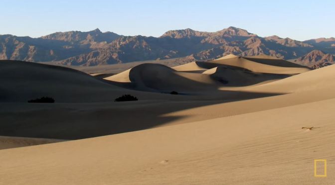
Aerial Views: Death Valley In Eastern California (4K)
Death Valley is a desert valley in Eastern California, in the northern Mojave Desert, bordering the Great Basin Desert. During summer, it is one of the hottest places on Earth, along with deserts in the Middle East and the Sahara.

Views: Cities, Landmarks & Landscapes Of Egypt (8K)
Egypt, a country linking northeast Africa with the Middle East, dates to the time of the pharaohs. Millennia-old monuments sit along the fertile Nile River Valley, including Giza’s colossal Pyramids and Great Sphinx as well as Luxor’s hieroglyph-lined Karnak Temple and Valley of the Kings tombs.
Video timeline: 0:00 Khafre with Pyramid 0:08 Karnak temple 0:15 Cinematic view of Hatshepsut temple 0:21 Sphinx with blue sky 0:29 Cinematic view of Pyramids 0:37 Tomb ramses of Hieroglyphs 0:44 Edfu temple 0:53 Pyramids in Egypt 0:58 Sphinx Giza valley 1:05 Ancient in egypt 1:12 Sphinx in egypt 1:17 Obelisk pillar 1:24 big balloon in Luxor, egypt 1:27 Nile river 1:34 Cairo mosque 1:39 Beautiful Hieroglyphics 1:50 Aswan philae 1:58 Sea in El Gouna 2:06 Ocean in Hurghada 2:10 Sphinx with blue sky 2:13 Hieroglyphs 2:17 Pyramids 2:21 Hieroglyphs 2:29 Animated ancient 2:36 Sphinx with Pyramids 2:43 Pyramids in egypt 2:48 Great sphinx
The capital, Cairo, is home to Ottoman landmarks like Muhammad Ali Mosque and the Egyptian Museum, a trove of antiquities.

Aerial Short Films: ‘Mountains Song’
Mountains Song – is my latest short drone film. In this film the main subject are mountains of all sizes tall and short, with clouds and fog as a complimentary. I also wanted to experiment a bit with a post production and grading. I was inspired by Ansel Adams black and white contrasty landscape photos and wanted to create similar imagery, but with in a video. To my big surprise I found almost no b&w drone films, so I wanted to fix tat.
The subdued atmospheric sound from Ryan Taubet in my opinion compliments the airy scenery.
Filmed and Edited by: Vadim Sherbakov
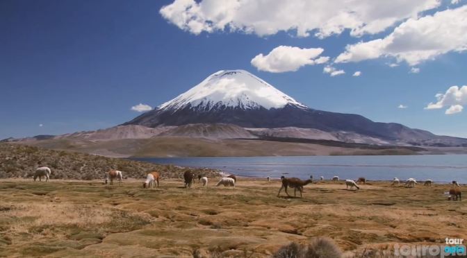
8K Views: The Mountains, Lakes And Cities Of Chile
Chile is a long, narrow country stretching along South America’s western edge, with more than 6,000km of Pacific Ocean coastline. Santiago, its capital, sits in a valley surrounded by the Andes and Chilean Coast Range mountains.
Video timeline: 0:00 Mountains and lake in torres 0:08 Salto del claro 0:15 Dry hills in chile 0:22 Santiago 0:29 Misty waterfall 0:34 Araucaria forests 0:42 Tagua lake 0:55 Salto del claro 1:05 Northern chile 1:14 Dry hills in chile 1:24 Rice farmer 1:30 Mother and Child War Memorial 1:37 Dry hills in chile 1:41 Santiago 1:48 Green forest 1:53 Torres del paine 1:58 Puerto montt los lagos 2:12 Chile child 2:23 Araucaria forests
The city’s palm-lined Plaza de Armas contains the neoclassical cathedral and the National History Museum. The massive Parque Metropolitano offers swimming pools, a botanical garden and zoo.
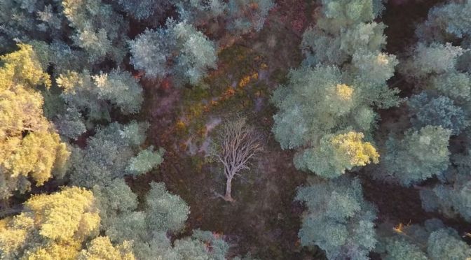
Woodland Views: North York Moors In England
The North York Moors is an upland area in north-eastern Yorkshire, England. It contains one of the largest expanses of heather moorland in the United Kingdom. The area was designated as a National Park in 1952, through the National Parks and Access to the Countryside Act 1949.
Woodland Sanctuary is a joint exhibition between myself and Joe Cornish. The work was gathered over the last 6 years, all of it within the North York Moors National Park. Using my archived footage, I’ve made this relaxing video of local woodland scenes which will play on a loop in the Sanctuary room of the exhibition. I’ve decided to share it online so that it can be enjoyed by all.
The exhibition consists of 9 themes which reflect the preoccupations and imaginative journeys of the photographers during their time in the woods. The images reflect the intense experience of studying trees in all weather conditions and all times of year.

Cover Preview: Outdoor Photography – June 2022
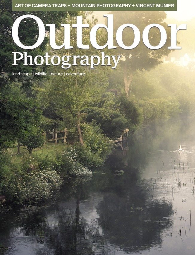
In Outdoor Photography issue 280
Chris Frost captures the magic of Dorset’s hidden woods
Essential tips for successful mountain photography
James Roddie introduces the art of camera trapping
Vincent Munier discusses his stunning new nature film
+

Timelapse Views: Canyons & Colors Of Moab, Utah
Filmed and Edited by: Ron Risman
This is Moab is a film that was designed to highlight the wide variety of landscapes that you can experience when you visit Moab, Utah – and most of these locations are not located in Arches or Canyonlands National Parks.
Moab Utah is a many things to many people, but what ever it is that brings you to Moab (vacation, off-roading, rock climbing, biking, hiking, photography, painting, rafting, camping) you may not realize that if you just visit the two national parks (Arches and Canyonlands) you’re missing out on 98% of what Moab has to offer.
The Bureau of Land Management (BLM) in Moab manages over 1.8 MILLION acres of breathtaking red rock canyons, cliffs, fins, spires and hoodoos – and all of this public land is located outside of the National Parks.
Then there’s the LaSal Mountains, the second largest in all of Utah – with elevations reaching 13,000 feet. Tired of the 100 degree desert heat? Take a drive on the LaSal Mountain Loop Rd and enjoy cooler weather and spectacular mountain scenery.
Moab, Utah is one of the most amazing locations you can visit – whether you’re seeking adventure, solitude, or anything in between. If you’re a painter, photographer, hiker, biker, rock climber, rafter, off-roader, or traveling in an RV or camper – Moab has what you’re looking for. As a photographer Moab offers some of the finest landscapes anywhere on earth – with millions of acres of red-rock sandstone arches, spires, fins, canyons, and hoodoos.
Moab is also home to the second tallest mountain range in Utah – the La Sal Mountains with peaks reaching over 13,000 feet in elevation. Often these peaks are snow-capped even in the spring and early Summer – making for a beautiful contrast between desert landscape and mountains. In summer take a short 1 hour drive from the desert climate of Moab with temperatures near 100 degrees to sitting under an Aspen grove on the La Sal mountains with temperatures in the mid 70’s.
Love stargazing? You’ll love the dark skies around Moab. Head into Arches National Park, Canyonlands National Park, or Dead Horse Point State Park and enjoy some of the darkest skies in the country. The International Dark Sky Association has designated these locations as dark-sky parks, and you’ll soon discover why. But don’t stop there – anytime you leave town, you’ll discover that the lack of any significant light pollution and the dry high-desert climate ensures a wonderful view of the night sky on most nights. You’ll also be happy to know that Moab is also one of the safest places to hang outdoors – as there really isn’t much in the way of predatory wildlife.
