
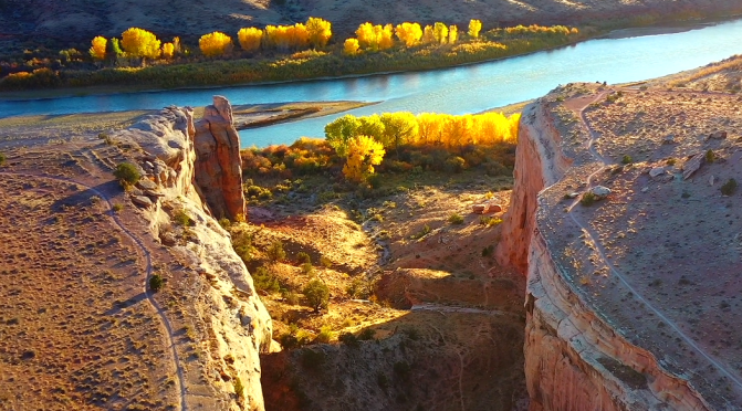
A landscape aerial film shot in Western Colorado and Utah, USA, featuring our beautiful planet during all four seasons. This project was shot during the last two years in remote locations.
Tag Archives: Utah
Utah Views: Landscapes, Landmarks & Cities (8K)
Utah is a state in the Mountain West subregion of the Western United States. Utah is a landlocked U.S. state bordered to its east by Colorado, to its northeast by Wyoming, to its north by Idaho, to its south by Arizona, and to its west by Nevada. Utah also touches a corner of New Mexico in the southeast.
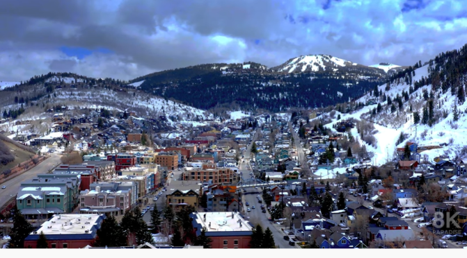
Video timeline: 0:00 1. Salt Lake City skyline at sunset with mountains behind 0:08 2. Park City Mountain Resort, Utah 0:16 3. Utah mountain landscape 0:22 4. Park City Mountain Resort 0:30 5. Horses at Zion National Park 0:38 6. Road through the desert and mountains of Utah 0:47 7. Amazing rock formations in Utah 0:56 8. Salt Lake City at night 1:03 9. Amazing rock formations in Utah 1:11 10. Utah Arches National Park on a sunny day 1:18 11. Stormy desert buttes and river near Moab, Utah 1:26 12. Butte landscape, Utah 1:34 13. Salt Lake City, Utah 1:40 14. Pink cliffs in Snow Canyon State Park, Utah 1:49 15. Salt Lake City capital building 1:57 16. Stunning red sandstone hoodoos in Bryce Canyon National Park 2:07 17. Colorado river highway 128, Utah 2:18 18. Salt Lake City skyline and cathedral 2:29 19. The Mars Desert Research Station (MDRS) in Utah 2:36 20. Colorado river highway 128, Utah 2:46 21. Sunny dry desert towards big rocky mountains and clear blue sky in Utah 2:55 22. Salt Lake City capitol building city skyline 3:03 23. Peaceful reflective water between canyons in Lake Powell 3:13 24. Salt Lake City Assembly Hall from Latter-day Saints 3:23 25. Mountain landscape in Utah 3:42 26. Cliff edge in Southern Utah 3:48 27. Utah Arches National Park at sunrise 3:58 28. Lake Powell rock formations and canyon walls 4:10 29. Salt Lake City skyline at sunset with mountains 4:20 30. Butte factory in Utah 4:30 31. Mexican Hat rock formation in Utah 4:41 32. Red Rock Mesa mountain cliffs in Red Rock desert, Utah 4:48 33. Utah Arches National Park on a sunny day 5:02 34. Lake Powell with canyons in the background 5:13 35. Salt Lake City capitol building 5:25 36. The Mars Desert Research Station (MDRS) in Utah 5:34 37. Utah mountain landscape 5:50 38. Winding road leading to unique Bears Ears, Utah 6:01 39. Rock formations in Paria, Utah 6:12 40. Texas Gulf Potash Pond One in Utah 6:28 41. Juniper trees in a vast desert in Central Utah 6:35 42. Red rock buttes and cliffs in Utah 6:49 43. Colorado river in the desert, Utah 7:04 44. Salt Lake City, Utah 7:27 45. Road in beautiful desert, Burr Trail canyon 7:33 46. Antelope Island, Utah 7:47 47. Empty desert road at sunrise in Monument Valley, Utah 7:59 48. Stunning red sandstone hoodoos in Bryce Canyon National Park 8:14 49. Utah Arches National Park on a sunny day 8:20 50. The Mars Desert Research Station (MDRS) in Utah 8:34 51. Utah Arches National Park at sunrise 8:41 52. Texas Gulf Potash Pond One in Utah 8:58 53. Utah Arches National Park at sunrise 9:06 54. Grand Canyon at Utah border 9:20 55. Rock formations in Paria, Utah 9:39 56. Famous sunny American desert highway road in Monuments Valley 9:53 57. Salt Lake City, Utah
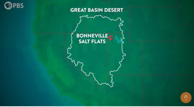
Views: The Bonneville Salt Flats In Northwest Utah
The Bonneville Salt Flats are perfect for speed. Every year, cars and motorcycles break land speed records on the flat expanse of the Bonneville Salt Flats. It’s been a tradition for more than a century, and racers have built a thriving community around the salt races. But how did these salt flats form, and why are they disappearing now?

Western Drought: Expect More Fires & Water Wars
As of mid-June, nearly three-quarters of the US’s West has been experiencing “severe,” “extreme,” or “exceptional” drought conditions. In addition to the states above, it also includes northern states like North Dakota and Montana.
Overall, climate change is playing a role. But there are smaller factors at play that are tied to climate change as well. Including…
- Not enough rain. The National Oceanic and Atmospheric Association (NOAA) said the Southwest’s 2020 monsoon season (read: ‘nonsoon’) was “the hottest and driest summer/monsoon season on record.” And the decrease in rainfall is having an impact on today’s drought (think: not enough water for crops, lakes, or reservoirs). And for the little rain that has fallen, it could dry up faster because of…
- Warmer temps. The NOAA dubbed 2020 the second-hottest year on record. And in late June, a record-breaking heat wave hit the Pacific Northwest, with the temperature reaching up to 112 degrees Fahrenheit in places like Portland, OR. (Psst…if you’re dealing with hot weather, here are some tips to stay safe.) Hotter, drier weather creates a thirsty environment, which speeds up evaporation. Rising temps are also causing snowpacks to melt faster, and they’re reportedly producing less runoff – a vital water resource. All of which means there’s less water available for communities and ecosystems.
Experts are also worried that the current dry and hot conditions will have a ripple effect, which brings us to wildfires. Last year’s West Coast wildfire season was the worst ever. Fires in California killed 31 people, burned more than 4 million acres, and destroyed thousands of buildings and structures. And this year, states like Arizona have seen an early start to their wildfire season. But the effects of the drought stretch even further.
Tours: Top Ten Places In The American Southwest
The Southwest is one of the most beautiful regions of America. From the turquoise waterfalls of Havasupai, to the unique rock formations of Moab, the Southwest has so many hidden gems waiting to be explored. Where is your favorite place in the Southwest?
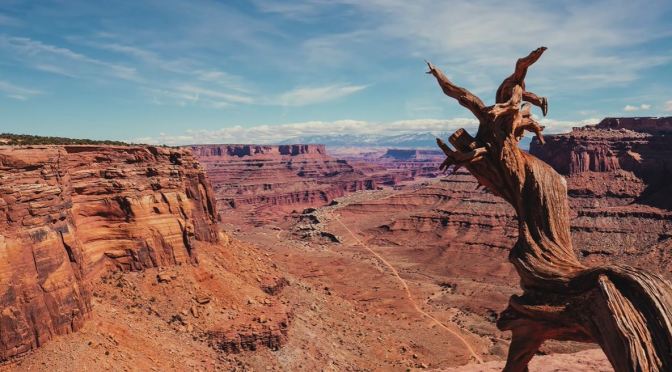
Aerial View: Canyonlands National Park, Utah (4K)
Canyonlands National Park in southeastern Utah is known for its dramatic desert landscape carved by the Colorado River. Island in the Sky is a huge, flat-topped mesa with panoramic overlooks. Other notable areas include the towering rock pinnacles known as the Needles, the remote canyons of the Maze and the Native American rock paintings in Horseshoe Canyon. Whitewater rapids flow through Cataract Canyon.
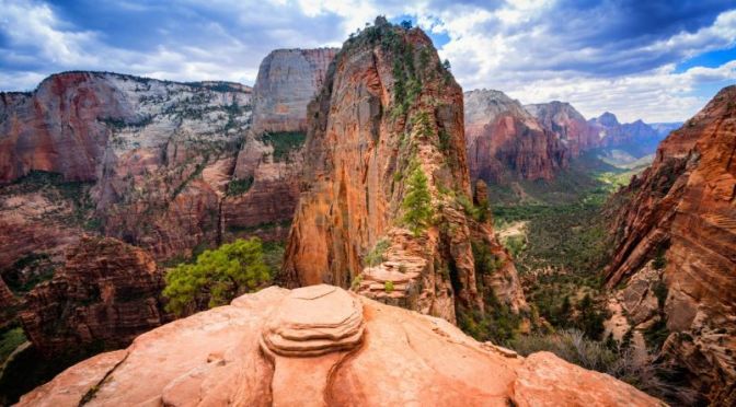
Views: Zion National Park, Southwestern Utah (4K)
Zion National Park is a southwest Utah nature preserve distinguished by Zion Canyon’s steep red cliffs. Zion Canyon Scenic Drive cuts through its main section, leading to forest trails along the Virgin River. The river flows to the Emerald Pools, which have waterfalls and a hanging garden. Also along the river, partly through deep chasms, is Zion Narrows wading hike.
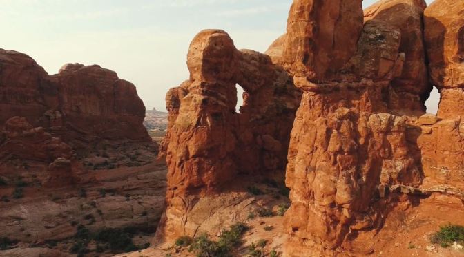
Views: Arches National Park – Utah (4K Video)
Arches National Park lies north of Moab in the state of Utah. Bordered by the Colorado River in the southeast, it’s known as the site of more than 2,000 natural sandstone arches, such as the massive, red-hued Delicate Arch in the east. Long, thin Landscape Arch stands in Devils Garden to the north. Other geological formations include Balanced Rock, towering over the desert landscape in the middle of the park.
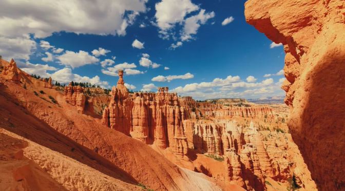
Views: Bryce Canyon National Park, Utah
Bryce Canyon National Park, a sprawling reserve in southern Utah, is known for crimson-colored hoodoos, which are spire-shaped rock formations. The park’s main road leads past the expansive Bryce Amphitheater, a hoodoo-filled depression lying below the Rim Trail hiking path. It has overlooks at Sunrise Point, Sunset Point, Inspiration Point and Bryce Point. Prime viewing times are around sunup and sundown.
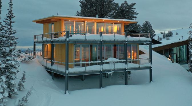
Mountain Views: ‘Chalet On Powder Mountain’ In Northern Utah (Video)
Chalet on Powder Mountain
This chalet is located just slightly north of the top of a gentle slope that stretches from north to south in the natural park in Powder Mountain, Utah, USA. It sits at the northern end of a cluster of chalets spread out to the south, and one can enjoy the view to the south from the second floor. It is a great place to access both the town and the ski resort, and enjoy the magnificent view to the north.


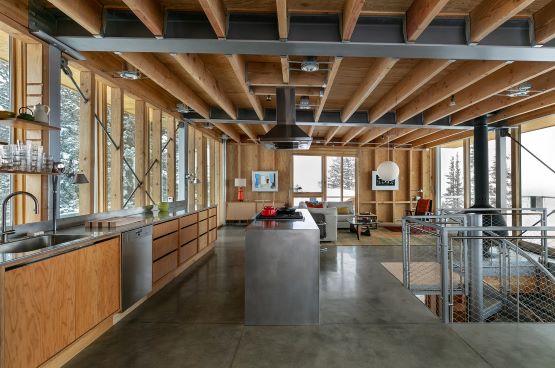
After skiing, they would step off the ski slope and approach the chalet from the south side of the site to take a break. They would go into the mud room, take off ski clothes and skis, hang them there to dry, take a shower on the same floor, change in on of the bedrooms, and go upstairs. The upper floor where one can enjoy the magnificent view on the north side has a spacious balcony resulted from the setback regulation, kitchen, dining room, and living room where they would enjoy the view, delicious food and drinks, light the fire and have a good time together after a long day of skiing. Since the building is located in a natural park, it is subject to very strict building regulations and the buildable area is small. This extremely compact building is designed to take up the maximum allowable volume. The compact size is perfect for experiencing the grandeur of nature, giving you a sense of being nestled in it.
Structurally, the lower floor is constructed with steel frames to maintain an appropriate distance between the slope and the building, and a highly insulated wooden structure is placed on top of the steel frames to protect the indoor environment. The expression of the wooden materials harmonizes and integrates with the surrounding land and stones in summer, and evokes the warmth of home against the white snow in winter.
Title: Chalet on Powder Mountain
Architect: Jo Nagasaka / Schemata Architects
Project team: Matthieu Darcourt, Ou Ueno
Collaboration: Lloyd Architects(AOR)
Location: Utah, USA
