Never seen before images of the detailed Everest Summit, C1, C2, C3 and C4. The Khumbu Icefall to the Western Cwm, all captured in stunning detail by the DJI Mavic 3.
Mount Everest is Earth’s highest mountain above sea level, located in the Mahalangur Himal sub-range of the Himalayas. The China–Nepal border runs across its summit point. Its elevation of 8,848.86 m was most recently established in 2020 by the Chinese and Nepali authorities.
Curieuse Island is a small granitic island 1.13 sq mi in the Seychelles close to the north coast of the island of Praslin. Curieuse is notable for its bare red earth intermingled with the unique coco de mer palms, one of the cultural icons of the Seychelles, only growing on the two neighboring islands.
Dublin, capital of the Republic of Ireland, is on Ireland’s east coast at the mouth of the River Liffey. Its historic buildings include Dublin Castle, dating to the 13th century, and imposing St Patrick’s Cathedral, founded in 1191. City parks include landscaped St Stephen’s Green and huge Phoenix Park, containing Dublin Zoo. The National Museum of Ireland explores Irish heritage and culture.
Carinthia is a southern Austrian region in the eastern Alps that encompasses Austria’s highest mountain, Grossglockner. It’s characterized by alpine lakes and mountains, as well as medieval buildings such as Hochosterwitz Castle. The region’s capital of Klagenfurt sits on the shores of huge Lake Wörthersee, surrounded by vineyards. Its central Alter Platz (Old Square) has many Renaissance buildings.
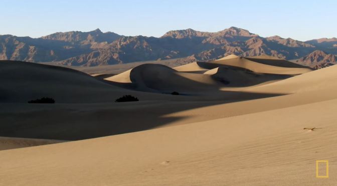
Death Valley is a desert valley in Eastern California, in the northern Mojave Desert, bordering the Great Basin Desert. During summer, it is one of the hottest places on Earth, along with deserts in the Middle East and the Sahara.
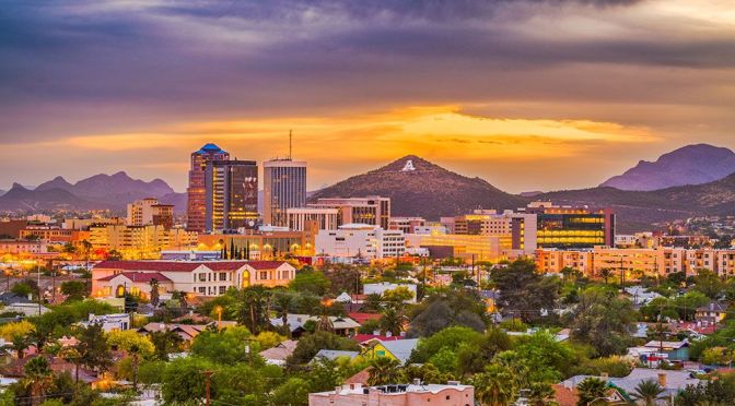
Tucson, city, seat (1864) of Pima county, southeastern Arizona, U.S. Tucson lies along the Santa Cruz River on a hilly plain of the Sonoran Desert that is rimmed by the Santa Catalina and other mountains. The city lies at an elevation of 2,410 feet (735 metres) and is situated about 115 miles (185 km) southeast of Phoenix.
Mountains Song – is my latest short drone film. In this film the main subject are mountains of all sizes tall and short, with clouds and fog as a complimentary. I also wanted to experiment a bit with a post production and grading. I was inspired by Ansel Adams black and white contrasty landscape photos and wanted to create similar imagery, but with in a video. To my big surprise I found almost no b&w drone films, so I wanted to fix tat.
The subdued atmospheric sound from Ryan Taubet in my opinion compliments the airy scenery.
Salvador, the capital of Brazil’s northeastern state of Bahia, is known for its Portuguese colonial architecture, Afro-Brazilian culture and a tropical coastline. The Pelourinho neighborhood is its historic heart, with cobblestone alleys opening onto large squares, colorful buildings and baroque churches such as São Francisco, featuring gilt woodwork.
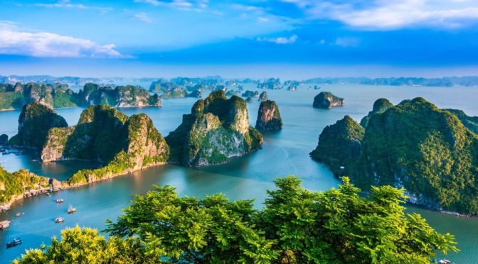
Hạ Long Bay, in northeast Vietnam, is known for its emerald waters and thousands of towering limestone islands topped by rainforests. Junk boat tours and sea kayak expeditions take visitors past islands named for their shapes, including Stone Dog and Teapot islets. The region is popular for scuba diving, rock climbing and hiking, particularly in mountainous Cát Bà National Park.
South Carolina is a southeastern U.S. state known for its shoreline of subtropical beaches and marshlike sea islands. Coastal Charleston is a historic city, defined by pastel-colored houses, Old South plantations and Fort Sumter, where the Civil War’s opening shots were fired. To the north is the Grand Strand, a roughly 60-mile stretch of beachfront known for golf courses and the vacation town Myrtle Beach.
News, Views and Reviews For The Intellectually Curious