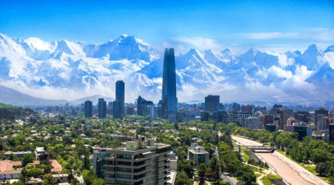
Santiago, capital of Chile. It lies on the canalized Mapocho River, with views of high Andean peaks to the east.
The city was founded as Santiago del Nuevo Extremo (“Santiago of the New Frontier”) in 1541 by the Spanish conquistador Pedro de Valdivia. The area was inhabited by the Picunche Indians, who were placed under the rule of the Spanish settlers. The original city site was limited by the two surrounding arms of the Mapocho River and by Huelén (renamed Santa Lucía) Hill to the east, which served as a lookout.
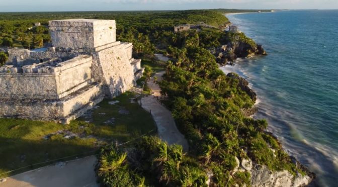
Yucatán, estado (state), southeastern Mexico. Occupying part of the northern Yucatán Peninsula, it is bounded to the north by the Gulf of Mexico, to the east and southeast by the state of Quintana Roo, and to the southwest and west by the state of Campeche. The state capital and chief commercial centre is Mérida.
The state’s relief includes coastal wetlands, semiarid hills and plains, and limestone lowlands dotted with cenotes (water-filled sinkholes). In pre-Hispanic times the peninsula was an Olmec and Maya cultural hearth, as evidenced by the monumental ruins of Chichén Itzá and Uxmal; each has been designated a UNESCOWorld Heritage site, in 1988 and 1996, respectively. Among the other numerous ruined cities are Chumul, Ek Balam, and Sayil. Strong resistance to the Spanish conquest lasted in the area from 1527 until the 1540s. Yucatán occupied the entire peninsula when it became a state in 1824, but following a series of insurrections, its territory was reduced with the loss of Campeche in 1857 (ratified in 1858) and Quintana Roo in 1902. Later boundary changes reduced the state to its present size.
The white sandy Thung Wua Laen Beach is 2 km long and lies 13 km North of Chumphon in Southern Thailand.
The “beach of the bull running across the field” is also signposted ‘Thung Wualan’. According to the legend the beach was named by hunters who killed a wild bull. This bull was so strong that it freed itself and escaped while it was being skinned. It ran “across the field”.
Beach chairs and jet skis are not allowed on this beach. The priority here lies on environmentally friendly tourist projects where they try to keep a natural balance.
With a rich history in agriculture and shipbuilding, Kennebunk today retains her connection to the land and sea. With easy access to the ocean, river, and wooded trails, the town is one of those special communities that seems to have it all, even the prestige of name (there is only one Kennebunk in the country).
Kennebunk balances a rural feel with true convenience – Portland is only 25 miles away and catching the Downeaster train in Wells makes the commute to Boston a snap. Featured on the town seal is the Lafayette Elm, which was planted to commemorate General Lafayette’s 1825 visit to Kennebunk. The handsome tree is one of the only survivors of the Dutch Elm that destroyed hundreds of trees that once lined Kennebunk’s streets.
The residents are a bit like the mighty tree: able to withstand the changing of seasons and passing of time with a sense of quiet nobility. In this tight-knit, laid-back community, it’s easy to be a good and helpful neighbor.
The Lake District is a region and national park in Cumbria in northwest England. A popular vacation destination, it’s known for its glacial ribbon lakes, rugged fell mountains and historic literary associations. Market towns such as Kendal, Ambleside and Keswick on scenic Derwentwater are bases for exploring the area and home to traditional inns, galleries of local art and outdoor equipment shops.
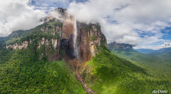
5.4K UltraHD aerial footage of my drone flights at the Angel Falls in Canaima National Park (UNESCO World Heritage site in Gran Sabana region of Bolivar State in Venezuela). Filmed in 2022.
Video timeline: ▶️ Drone – Angel Falls 2022 0:00 ▶️ Salto Angel 1:15 ▶️ Canaima National Park Venezuela 2:30
Angel Falls, Spanish Salto Ángel, also called Salto Churún Merú, waterfall in the Guiana Highlands in Bolívar state, southeastern Venezuela, on the Churún River, a tributary of the Caroní, 160 miles (260 km) southeast of Ciudad Bolívar. The highest waterfall in the world, the cataract drops 3,212 feet (979 metres) and is 500 feet (150 metres) wide at the base. It leaps from a flat-topped plateau, Auyán-Tepuí (“Devils Mountain”), barely making contact with the sheer face. The falls are located in Canaima National Park, and, because of the dense jungle surrounding the falls, they are best seen from the air.
The falls, first sighted by outsiders in the 1930s, were named for James Angel, an American adventurer who crash-landed his plane on a nearby mesa in 1937. In late 2009 Venezuelan Pres. Hugo Chávez declared that the falls should be referred to as Kerepakupai Merú, an indigenous name.
Bolzano is a city in the South Tyrol province of north Italy, set in a valley amid hilly vineyards. It’s a gateway to the Dolomites mountain range in the Italian Alps. In the medieval city center, the South Tyrol Museum of Archaeology features the Neolithic mummy called Ötzi the Iceman. Nearby is the imposing 13th-century Mareccio Castle, and the Duomo di Bolzano cathedral with its Romanesque and Gothic architecture.
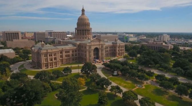
Austin is the state capital of Texas, an inland city bordering the Hill Country region. Home to the University of Texas flagship campus, Austin is known for its eclectic live-music scene centered around country, blues and rock. Its many parks and lakes are popular for hiking, biking, swimming and boating. South of the city, Formula One’s Circuit of the Americas raceway has hosted the United States Grand Prix.
Wichita, city, seat (1870) of Sedgwick county, south-central Kansas, U.S. It lies on the Arkansas River near the mouth of the Little Arkansas, about 140 miles (225 km) southwest of Topeka. The city site is a gently rolling plain at an elevation of about 1,300 feet (400 metres). Summers are hot and winters cool; precipitation is moderate and falls mainly during the warm months.
Wichita, the largest city in the state, is at the heart of a three-county metropolitan area. Nearby communities include Park City (north), Andover (east), and Derby and Haysville (south). Inc. city, 1871. Area city, 139 square miles (360 square km). Pop. (2010) 382,368; Wichita Metro Area, 623,061; (2020) 397,532...
Wichita was founded in 1864 as a trading post on the site of a village of the Wichita Indians. It owed its early development to the Texascattle trade along the Chisholm Trail and to the rapid spread of agricultural settlement along the Atchison, Topeka and Santa Fe Railway, then under construction. In its early years Wichita was a stopover on cattle drives to Abilene (Kansas) and other points as the railroad moved west; in 1872 the line reached Wichita, and the city became a major cattle-shipping centre. By 1875 farmers’ fences were obstructing the movement of beef herds, but grain became an important commodity.
We are greatly inspired by nature’s beauty. And that feeling was especially strong while we were visiting Indonesia. At first, we couldn’t even believe that all this is real. Giant trees with leaves as big as people. Beaches with waves higher than most houses. Volcanoes surrounded by deserted valleys with unbelievable colours.
Our project aims to immerse the viewer into that fantastic atmosphere: with every frame of video footage, with every note of orchestral music. We want you to really feel the overwhelming beauty of those flights. We have been working on this project for a 1,5 year. And every day of work brought us back to those places and the emotions we experienced.
We lived on Java and Bali for 4 months and it allowed us to feel the islands, to absorb the local atmosphere. It helped us to find the best angles and composition to capture the immense beauty of Indonesia. And now we’re finally ready to share it with you.
News, Views and Reviews For The Intellectually Curious