

Ireland is an island in the North Atlantic. It is separated from Great Britain to its east by the North Channel, the Irish Sea, and St George’s Channel. Ireland is the second-largest island of the British Isles, the third-largest in Europe, and the twentieth-largest on Earth.
Tag Archives: Aerial Travel Videos

Aerial Views: Omaha – Eastern Nebraska (4K)
Omaha is a city in the U.S. state of Nebraska, on the Missouri River close to the Iowa border. A stop on the Lewis & Clark National Historic Trail, it’s known for its pioneer history, museums and cultural centers. The Henry Doorly Zoo and Aquarium spearheads conservation work and features a big cat complex as well as indoor jungle, rainforest and desert habitats.

Aerial Views: Crimea Peninsula, Black Sea
Crimea is a peninsula located on the northern coast of the Black Sea in Eastern Europe that is almost completely surrounded by both the Black Sea and the smaller Sea of Azov to the northeast.
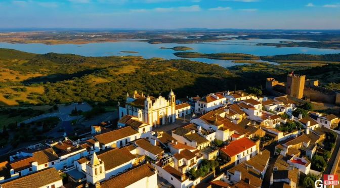
Aerial Views: The Cities & Landscapes Of Portugal
Portugal is a southern European country on the Iberian Peninsula, bordering Spain. Its location on the Atlantic Ocean has influenced many aspects of its culture: salt cod and grilled sardines are national dishes, the Algarve’s beaches are a major destination and much of the nation’s architecture dates to the 1500s–1800s, when Portugal had a powerful maritime empire.

Aerial Views: Village Of Coculina, Burgos, Spain
Burgos, a provincial capital in Spain’s autonomous community of Castile and León, is marked by its intact medieval architecture. Its most recognizable landmark is the French Gothic Cathedral of St. Mary, whose 3 main doorways are flanked by ornamented bell towers. Inside is the Chapel of Condestable, decorated with figures of saints, and the tomb of El Cid (Rodrigo Díaz de Vivar), the 11th-century military commander.
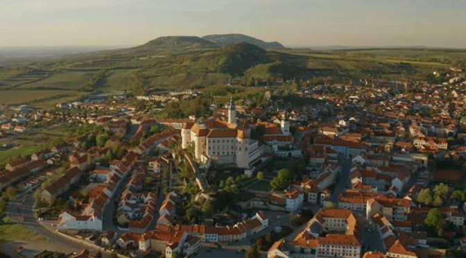
Aerial Views: Mikulov – Czech Republic (4K Video)
Mikulov is a town in Břeclav District in the South Moravian Region of the Czech Republic. It has about 7,500 inhabitants. The historic centre of Mikulov is well preserved and historically significant and is protected by law as urban monument reservation.

Aerial Views: The Cities & Landscapes Of Tanzania
Tanzania is an East African country known for its vast wilderness areas. They include the plains of Serengeti National Park, a safari mecca populated by the “big five” game (elephant, lion, leopard, buffalo, rhino), and Kilimanjaro National Park, home to Africa’s highest mountain. Offshore lie the tropical islands of Zanzibar, with Arabic influences, and Mafia, with a marine park home to whale sharks and coral reefs.

Aerial Views: The Many Landscapes Of Iceland
Iceland, a Nordic island nation, is defined by its dramatic landscape with volcanoes, geysers, hot springs and lava fields. Massive glaciers are protected in Vatnajökull and Snæfellsjökull national parks. Most of the population lives in the capital, Reykjavik, which runs on geothermal power and is home to the National and Saga museums, tracing Iceland’s Viking history.

Aerial Views: Cities And Islands Of Indonesia (4K)
Indonesia, officially the Republic of Indonesia, is a country in Southeast Asia and Oceania between the Indian and Pacific oceans. It consists of over seventeen thousand islands, including Sumatra, Java, Sulawesi, and parts of Borneo and New Guinea.
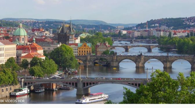
Aerial Views: Czech Republic (8K Video)
The Czech Republic, also known by its short-form name, Czechia, formerly known as Bohemia, is a landlocked country in Central Europe. It is bordered by Austria to the south, Germany to the west, Poland to the northeast, and Slovakia to the east.
