
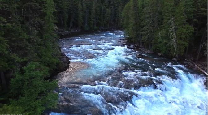
Montana is a western state defined by its diverse terrain ranging from the Rocky Mountains to the Great Plains. Its wide-open spaces include Glacier National Park, a vast wilderness preserve that passes into Canada. The park’s many snow-capped peaks, lakes and alpine hiking trails are showcased along its famed Going-to-the-Sun Road, stretching 50 miles.
Tag Archives: Western United States
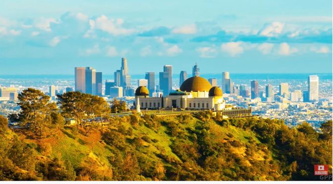
Aerial Views: Los Angeles, Southern California (4K)
Los Angeles is a sprawling Southern California city and the center of the nation’s film and television industry. Near its iconic Hollywood sign, studios such as Paramount Pictures, Universal and Warner Brothers offer behind-the-scenes tours. On Hollywood Boulevard, TCL Chinese Theatre displays celebrities’ hand- and footprints, the Walk of Fame honors thousands of luminaries and vendors sell maps to stars’ homes.
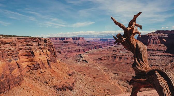
Aerial View: Canyonlands National Park, Utah (4K)
Canyonlands National Park in southeastern Utah is known for its dramatic desert landscape carved by the Colorado River. Island in the Sky is a huge, flat-topped mesa with panoramic overlooks. Other notable areas include the towering rock pinnacles known as the Needles, the remote canyons of the Maze and the Native American rock paintings in Horseshoe Canyon. Whitewater rapids flow through Cataract Canyon.
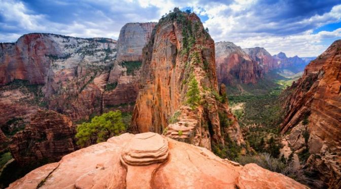
Views: Zion National Park, Southwestern Utah (4K)
Zion National Park is a southwest Utah nature preserve distinguished by Zion Canyon’s steep red cliffs. Zion Canyon Scenic Drive cuts through its main section, leading to forest trails along the Virgin River. The river flows to the Emerald Pools, which have waterfalls and a hanging garden. Also along the river, partly through deep chasms, is Zion Narrows wading hike.
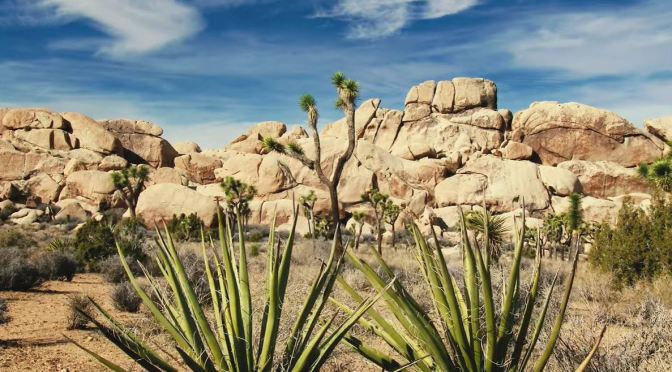
California Views: Joshua Tree National Park (4K)
Joshua Tree National Park is an American national park in southeastern California, east of Los Angeles and near Palm Springs. It is named after the Joshua trees (Yucca brevifolia) native to the Mojave Desert.
Originally declared a national monument in 1936, Joshua Tree was redesignated as a national park in 1994 when the U.S. Congress passed the California Desert Protection Act. Encompassing a total of 790,636 acres (1,235.4 sq mi; 3,199.6 km2) – slightly larger than the state of Rhode Island – the park includes 429,690 acres (671.4 sq mi; 1,738.9 km2) of designated wilderness.
Straddling San Bernardino and Riverside Counties, the park includes parts of two deserts, each an ecosystem whose characteristics are determined primarily by elevation: the higher Mojave Desert and the lower Colorado Desert. The Little San Bernardino Mountains traverse the southwest edge of the park.SHOW LESS

Views: Yosemite National Park – California (Video)
“Sunday Morning” takes us amidst the splendors of Yosemite National Park in California. Videographer: Scot Miller.
Yosemite National Park is in California’s Sierra Nevada mountains. It’s famed for its giant, ancient sequoia trees, and for Tunnel View, the iconic vista of towering Bridalveil Fall and the granite cliffs of El Capitan and Half Dome. In Yosemite Village are shops, restaurants, lodging, the Yosemite Museum and the Ansel Adams Gallery, with prints of the photographer’s renowned black-and-white landscapes of the area.
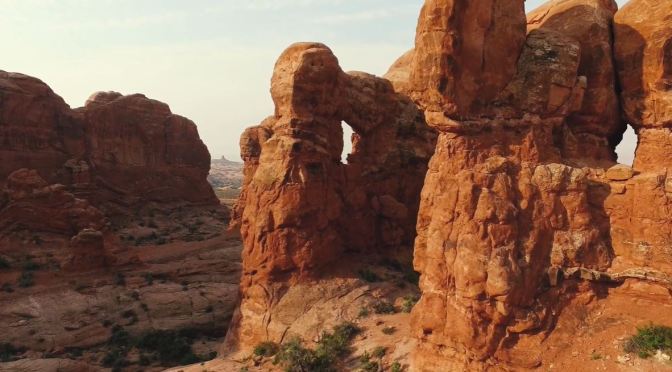
Views: Arches National Park – Utah (4K Video)
Arches National Park lies north of Moab in the state of Utah. Bordered by the Colorado River in the southeast, it’s known as the site of more than 2,000 natural sandstone arches, such as the massive, red-hued Delicate Arch in the east. Long, thin Landscape Arch stands in Devils Garden to the north. Other geological formations include Balanced Rock, towering over the desert landscape in the middle of the park.
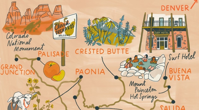
Road Trips: 3-Day Drive From Denver To Grand Junction, Colorado

May 13, 2021 10:47 am ET
Day 1: Denver to Salida
175 miles
Breakfast from Crema Coffee House (cremacoffeehouse.net) fuels the 2-hour-15-minute launch out of Denver’s orbit and into the mountains toward Buena Vista (“BYOO-nuh Vista” if you want to blend in). Along the Arkansas River, the town is a jumping-in point for kayakers, white-water rafters and stand-up paddleboarders (which is why you see so many signs asking you “SUP?”). If the rapids look too rapid, stroll instead along the banks in South Main, a meticulous neighborhood of gabled homes and shops that feels slightly staged but nonetheless stylish. Pop into the bar at the Surf Hotel, which anchors the area, for a refreshment on the wraparound balcony that overlooks the river (surfhotel.com).


Day 2: Salida to Paonia
217 miles
Show no restraint when selecting your breakfast items at Salida’s Little Red Hen Bakery (littleredhensalida.com). The drive west over Monarch Pass offers a panorama of the Sawatch mountain range as you cross the Continental Divide, the boundary that decides whether a river flows east or west. Continue on to Crested Butte, carved with plenty of hiking and biking paths. During the Crested Butte Wildflower Festival, July 9-18, local guides lead walks to the lushest spots, including the Rustler Gulch and Beckwith Pass trails (crestedbuttewildflowerfestival.org). Back in town, brightly painted buildings along Elk Avenue host convivial places such as Secret Stash (secretstash.com), which serves cheeky pizzas like the Booty Call (a heap of meat).

Day 3: Paonia to Grand Junction
282 miles
Before leaving Paonia, stock the car with tamales, honey and cider from Big B’s store and cafe, which sits steps away from their apple orchard (bigbs.com). Then drive over to Western Culture Farmstead & Creamery for some fresh feta and chevre and to coo over the adorable baby goats (westernculturefarmstead.com). It’s 2½ hours south to Telluride, sitting in a box canyon of 13ers and 14ers in a landscape that could be Switzerland’s stunt double. The emerald peaks crowd around this former mining town, now an upscale enclave of art galleries, cafes and shops. Get a lay of the land aboard the town’s free gondola, which lifts riders 1,750 feet above the valley floor. By late afternoon, the final leg of this tour sends you north 2.5 hours to Palisade, where in summer, orchards all over burst with the town’s prized peaches. Then, with space left on your camera-phone for one more astonishing landmass, take the scenic Rim Rock Drive through Colorado National Monument, 32 square miles of sandstone plateaus and rock formations with plenty of roadside overlooks along the route.
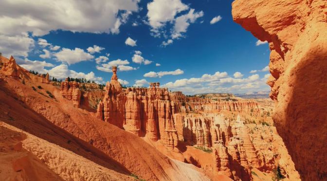
Views: Bryce Canyon National Park, Utah
Bryce Canyon National Park, a sprawling reserve in southern Utah, is known for crimson-colored hoodoos, which are spire-shaped rock formations. The park’s main road leads past the expansive Bryce Amphitheater, a hoodoo-filled depression lying below the Rim Trail hiking path. It has overlooks at Sunrise Point, Sunset Point, Inspiration Point and Bryce Point. Prime viewing times are around sunup and sundown.

Views: ‘Winding River Ranch – Colorado’ (Video)
Winding River Ranch is located less than 30 miles from Buena Vista, Buena Vista Central Colorado Regional Airport and 10 minutes by paved State Highway 285 south of Fairplay. It encompasses a highly diverse block of 5,748± acres (3,780± deeded) that lies at 9,300 feet just below the continental divide which includes some of Colorado’s famous 14,000-foot peaks. The lower reaches of the ranch include a rich wetland complex that supports nearly five miles of world-class private fishing on the highly regarded South Fork of the South Platte River. The upper reaches of the ranch include steeper, timbered terrain that offers private trophy quality elk and deer hunting – with rare hunting tags. There is enough land to support modest hay production, summer grazing for livestock and horses and three irrigated food plots, although fish and wildlife are the crop of choice for the current owners.
