

Saint Moritz, a town, or Gemeinde (commune), Graubünden canton, southeastern Switzerland. Saint Moritz lies in the Oberengadin (Upper Inn Valley) and is surrounded by magnificent Alpine peaks. The town consists of the Dorf (village), the Bad (spa), and the hamlets of Suvretta and Champfèr. Originally known for its curative mineral springs, it became a fashionable spa and summer resort in the 17th century. Since the late 19th century, it has developed as one of the world’s most famous winter-sport centres and was the scene of the Winter Olympic Games in 1928 and 1948. The resort is on an international highway, is linked by rail with international lines, and has an airport at Samedan, just northeast. Saint Moritz depends on tourism and the hotel industry.
Tag Archives: 4K Videos

Walking Tour: Leuven In Central Belgium (4K)
Leuven is a city east of Brussels, Belgium, known for its breweries. On a central square is the 15th-century town hall, with its tall spires. The building is decorated with hundreds of statues of local figures, biblical characters and saints. Opposite, the late Gothic St. Peter’s Church houses a “Last Supper” by the Flemish Primitive painter Dieric Bouts. Nearby, Oude Markt is a long square lined with bars and cafes.
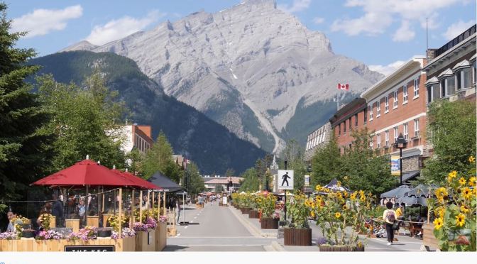
Resort Town Walks: Banff In Southwestern Canada
Banff is a resort town in the province of Alberta, located within Banff National Park. The peaks of Mt. Rundle and Mt. Cascade, part of the Rocky Mountains, dominate its skyline. On Banff Avenue, the main thoroughfare, boutiques and restaurants mix with château-style hotels and souvenir shops. The surrounding 6,500 square kilometres of parkland are home to wildlife including elk and grizzly bears.

Summer Walks: Santorini In The Aegean Sea, Greece
Thera, Modern Greek Thíra, also called Santorin, or Santoríni, island, southernmost island of the Cyclades (Modern Greek: Kykládes) group, southeastern Greece, in the Aegean Sea, sometimes included in the Southern Sporades group. It constitutes a dímos (municipality) within the South Aegean (Nótio Aigaío) periféreia (region).
Geologically, Thera is the remaining eastern half of an exploded volcano. Its bow-shaped rim and the remnant isles of Thirasía and Aspronísi form an open lagoon that measures 37 miles (60 km) in circumference. In the centre of the lagoon are two active volcanic islets, Néa Kaméni (“New Burnt Island”) and Palaía Kaméni (“Old Burnt Island”). Thera proper consists largely of lava and pumice, the latter of which is the island’s main export. Red-wine grapes are also grown. The lagoon is rimmed by red-, white-, and black-striped volcanic cliffs rising to almost 1,000 feet (300 metres). The summit of Thera is the 1,857-foot (566-metre) limestone Mount Profítis Ilías in the southeast. The chief town, Thíra (locally called Firá), was badly damaged by an earthquake in 1956. Other settlements include Emboríon and Pírgos to the south and the port of Oía at the north entrance to the lagoon, which was destroyed by the 1956 earthquake.

Walking Tour: Loches In The Loire Valley, France
As a town of Art and History, Loches cultivates the art of strolling around, from one street to the next, stopping to look at views of the inaccessible courtyards of the beautiful residences, the Indre River, the bell towers and the elegant surrounding countryside.
A medieval keep, royal apartments from the Renaissance period: in the royal city of Loches, you travel through history in just a few dozen metres.
So close to the great châteaux, and so far from the tumult of the cities, southern Touraine is a wonderful breath of fresh air, brimming with authenticity and charm. A sensitive natural area, the Louroux lake is a good example.
Filmed in Summer of 2022.

Walking Tour: Szeged In Southern Hungary (4K)
Szeged, city with county status and seat of Csongrád megye (county), southeastern Hungary. It lies on the Tisza River, west (downstream) of its confluence with the Maros and a few miles from the intersection of Hungary, Romania, and Serbia.
Szeged was a military stronghold and trade centre in the time of the Árpád kings (10th–15th century) and was sacked by the Tatars and the Turks. Flourishing as a centre of commerce, it was one of Hungary’s largest cities in the early 16th century, though it suffered under Turkish rule in the late 16th century and under Austrian rule from the late 17th century.
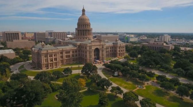
Aerial City Views: Austin – The Capital Of Texas (4K)
Austin is the state capital of Texas, an inland city bordering the Hill Country region. Home to the University of Texas flagship campus, Austin is known for its eclectic live-music scene centered around country, blues and rock. Its many parks and lakes are popular for hiking, biking, swimming and boating. South of the city, Formula One’s Circuit of the Americas raceway has hosted the United States Grand Prix.
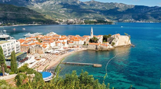
Walking Tours: Budva In Southwest Montenegro
Budva is a town in Montenegro on the Adriatic Sea. Part of the Budva Riviera, it’s known for sandy beaches and nightlife. Stone walls built by the Venetians surround the narrow streets of the medieval old town (Stari Grad). This historic district is home to a seaside citadel and religious sites such as the Church of Santa Maria in Punta, established in the 9th century.
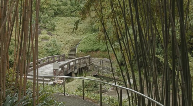
Summer Walks: A Bamboo Path At Otokuni In Kyoto
After the rain, the bamboo grove is the perfect time to feel the smell of fertile soil and bamboo. But please beware of mosquitoes during the summer. At Tennōzan, there was a battle that marked a turning point in Japanese history.
Even today, important days are sometimes referred to as Tennōzan. Komyo-ji Temple attracts a lot of tourists during the fall foliage season. In the fresh green season, you can enjoy a relaxing walk without worrying about the surroundings.
Video timeline: 00:00 タイトル(Title) 00:11 竹の径(Bamboo Path at Otokuni) 02:04 洛西竹林公園(Kyoto Bamboo Park) 03:25 大山崎竹林の小径(Bamboo Path at Oyamazaki) 04:48 天王山散策(Walking Around Tennōzan) 05:21 宝積寺(Hoshaku-ji Temple) 06:15 観音寺 (Kannon-ji Temple) 06:48 天王山(Mount Tennōzan) 08:00 自玉手祭来酒解神社(Sakatoke Shrine) 08:32 光明寺(Komyo-ji Temple)

Aerial City Views: Wichita In Central Kansas (4K)
Wichita, city, seat (1870) of Sedgwick county, south-central Kansas, U.S. It lies on the Arkansas River near the mouth of the Little Arkansas, about 140 miles (225 km) southwest of Topeka. The city site is a gently rolling plain at an elevation of about 1,300 feet (400 metres). Summers are hot and winters cool; precipitation is moderate and falls mainly during the warm months.
Wichita, the largest city in the state, is at the heart of a three-county metropolitan area. Nearby communities include Park City (north), Andover (east), and Derby and Haysville (south). Inc. city, 1871. Area city, 139 square miles (360 square km). Pop. (2010) 382,368; Wichita Metro Area, 623,061; (2020) 397,532...
Wichita was founded in 1864 as a trading post on the site of a village of the Wichita Indians. It owed its early development to the Texas cattle trade along the Chisholm Trail and to the rapid spread of agricultural settlement along the Atchison, Topeka and Santa Fe Railway, then under construction. In its early years Wichita was a stopover on cattle drives to Abilene (Kansas) and other points as the railroad moved west; in 1872 the line reached Wichita, and the city became a major cattle-shipping centre. By 1875 farmers’ fences were obstructing the movement of beef herds, but grain became an important commodity.
