Tag Archives: Hiking Tours

Hike: Liechtensteinklamm Gorge, Alpine Austria (8K)

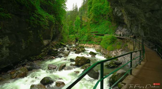
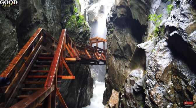
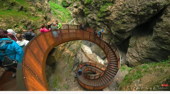
Liechtensteinklamm at the entrance to Grossarltal in St. Johann im Pongau is one of the deepest and longest gorges in the Alps. Allow yourself to be enchanted by the mighty thunder of the waterfall, by the lush green of the moss-covered rocks and the fine mists of water that conjure up rainbows.

Set out on a walk along safe wooden boardwalks through the gorge, which takes around 45 minutes one way. Our tip: Since you are bound to get wet inside the Liechteinsteinklamm, we recommend saving this trip for a day when the weather is not quite so marvelous. Unless, of course, you are looking for a pleasant way to cool down on a hot summer’s day.

GEOLOGY OF THE LIECHTENSTEINKLAMM: Totaling 4,000 meters, this gorge is one of the longest in the Alps, with around 1,000 meters accessible to visitors. The rock walls of the gorge are as much as 300 meters deep. At some points, the gorge is just a few meters wide. At the end of the gorge, a waterfall thunders towards the valley below.

Hikes: Breitachklamm Gorge In The Allgäu, Southern Germany (8K)

The Breitachklamm is a gorge created by the river Breitach in the Allgäu region in Southern Germany. It is located at the exit of the Kleinwalsertal near Tiefenbach, a city district of Oberstdorf. It is one of the deepest gorges of the Bavarian Alps and the deepest rocky gorge of Central Europe.

Every year around 300.000 visitors walk the 2.5 km long path through the gorge. The upper entrance of the Breitachklamm is located near the Walserschanz in Austria, with limited parking space, whereas the lower one in Oberstdorf-Tiefenbach offers a visitor center and ample parking. The Breitachklamm was formed only during the last 10,000 years after the Würm ice age. Glaciers had eroded soft rocks, and hard rocks remained. When the glaciers had melted, the Breitach river had to grind its way through the hard rocks, over a distance of 2.5 km and up to 150 metres (490 ft) deep.

Trail Hikes: Maroon Bells On Crater Lake, Colorado

The Maroon Bells are two peaks in the Elk Mountains, Maroon Peak and North Maroon Peak, separated by about half a kilometer. The mountains are on the border between Pitkin County and Gunnison County, Colorado, United States, about 12 miles southwest of Aspen. Both peaks are fourteeners. 

Hiking Tours: Sigmund-Thun Gorge In Austria (4K)

Where tremendous glaciers once covered the land, today one of Austria’s most astonishing spectacles of nature awaits amazed visitors. The gorge in Kaprun combines breathtaking beauty with mystical scenery and experiences that leave lasting memories.

Some 14,000 years ago, during the late ice age, a glacier completely covered the valley of Kaprun and gorged its way through the calcareous schist rocks of the Maiskogel and the Bürgkogel mountains. When the glacier melted, it left behind a gorge through which the river Ache of Kaprun ran. The river dug itself 32 metres deep into the ground and left behind strikingly smooth surfaces and natural whirlpools. Visitors move along narrow rock faces across wooden catwalks and numerous other bridges. Make sure not to miss the white water spectacle of Kaprun’s Ache River!


Hiking Views: The ‘Tell Trail’ In Switzerland (4K)

The new long-distance path Tell-Trail wends its way across the scenic Lucerne-Lake Lucerne region – from Altdorf up to the Brienzer Rothorn. In eight stages, the trail passes by glittering mountain lakes, through historic villages and world-renowned towns, and takes in the “Big 6” mountains of central Switzerland: Fronalpstock (Stoos), Rigi, Pilatus, Stanserhorn, Titlis and Brienzer Rothorn. The varied flora and fauna and the spectacular mountain landscape are constant features of the itinerary. Stage 5, from Stans to Engelberg, is particularly impressive.

If the good William Tell had had more time, he would have chosen this route through Central Switzerland. The Tell Trail leads you on spectacular high-altitude paths, into small side valleys and along dreamy rippling rivers. You will discover the most famous vantage points and the most beautiful places in Central Switzerland.

You hike in a wide arc from the Tell monument in Altdorf to the Muotathal, storm Stoos, Rigi and Mount Pilatus and finish the tour after a visit to Engelberg and Melchsee-Frutt on the Brienzer Rothorn. The hikes are demanding and the views are dazzling: If it weren’t for the landvogt Gessler, Wilhelm and Walter would have loved to take on this tour.

360° Hikes: Table Mountain In Alberta, Canada (Video)

Immerse yourself in Alberta’s wide-open spaces in this 360-degree experience as National Geographic Travel Photographer Kahli April hikes to Table Mountain in Castle Provincial Park. Follow her as she takes the trail through lush Aspen forest, up rocky scrambles and past waterfalls. At the summit, the wide flat table-like plateau (from where the mountain gets its name) opens up panoramic views from the vast prairies on one side to the peaks of the Canadian Rockies on the other.

Hikes: Cache Lake In Yellowstone Park (4K)

Cache lake is a small and picturesque lake at the base of Electric Peak in the Gallatin BMA area of the park, and it is a short, roughly 12-mile round-trip hike to the lake and back.

This is a nice day hike that most people can do if you want to try experiencing the backcountry. You will see other people and horses on this hike but you can also see wildlife, including bears, if you hike the right way. I saw lots of grizzly tracks and saw a black bear on this hike. This hike is around 13 miles round trip and only about 1,000 vertical feet elevation gain. There is water all along this hike.

Hikes: ‘Mount Sodom’ – Judean Desert, Israel (4K)

Mount Sodom is a hill along the southwestern part of the Dead Sea in Israel; it is part of the Judaean Desert Nature Reserve.

The Judaean Desert or Judean Desert is a desert in Israel and the West Bank that lies east of Jerusalem and descends to the Dead Sea.

Hikes: ‘Mount Hollywood & Griffith Observatory’

Mount Hollywood is a fantastic, short hike in the Griffith Park area of Los Angeles. The hike leaves from Griffith Observatory and it has some of the best views in the city as you make your way up. Along the way, be sure to stop and take in the views of the Hollywood Sign, Captains Roost and Griffith Observatory. Let me know what you think about this hike in the comments.

Top Hikes: The ‘Curecanti National Recreation Area’ In West Colorado (Video)

Curecanti National Recreation Area is a National Park Service unit located on the Gunnison River in western Colorado. Established in 1965, Curecanti National Recreation Area is responsible for developing and managing recreational facilities on three reservoirs, Blue Mesa ReservoirMorrow Point Reservoir and Crystal Reservoir, constructed on the upper Gunnison River in the 1960s by the U.S. Bureau of Reclamation to better utilize the vital waters of the Colorado River and its major tributaries. A popular destination for boating and fishing, Curecanti offers visitors two marinas, traditional and group campgrounds, hiking trails, boat launches, and boat-in campsites. The state’s premiere lake trout and Kokanee salmon fisheries, Curecanti is a popular destination for boating and fishing, and is also a popular area for ice-fishing in the winter months.