

Bukhara is an ancient city in the central Asian country of Uzbekistan. It was a prominent stop on the Silk Road trade route between the East and the West, and a major medieval center for Islamic theology and culture. It still contains hundreds of well-preserved mosques, madrassas, bazaars and caravanserais, dating largely from the 9th to the 17th centuries.
Tag Archives: Aerial Views

Aerial Views: Brasilia – Capital Of Brazil (4K)
Brasília, inaugurated as Brazil’s capital in 1960, is a planned city distinguished by its white, modern architecture, chiefly designed by Oscar Niemeyer. Laid out in the shape of an airplane, its “fuselage” is the Monumental Axis, 2 wide avenues flanking a massive park. In the “cockpit” is Praça dos Três Poderes, named for the 3 branches of government surrounding it.
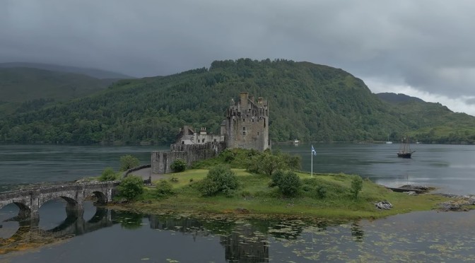
Aerial Views: Landmarks & Landscapes Of Scotland
Think ancient and mysterious standing stones, fine castles and lavish stately homes, striking architecture, derelict fortresses, world-famous feats of engineering and more! From the Scottish Borders to Orkney and from Fife to the Isle of Skye, fierce battles, cruel ridings and bloody risings were won and lost, lasting unions were forged, and new discoveries and world-changing inventions were made.
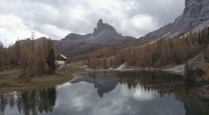
Aerial Views: Autumn 2022 In The Italian Dolomites
The Dolomites, also known as the Dolomite Mountains, Dolomite Alps or Dolomitic Alps, are a mountain range located in northeastern Italy. They form part of the Southern Limestone Alps and extend from the River Adige in the west to the Piave Valley in the east.

Aerial Views: Paris & The Jardin Du Luxembourg
The Jardin du Luxembourg, known in English as the Luxembourg Garden, colloquially referred to as the Jardin du Sénat, is located in the 6th arrondissement of Paris, France. Creation of the garden began in 1612 when Marie de’ Medici, the widow of King Henry IV, constructed the Luxembourg Palace as her new residence.

Aerial Views: Milan, Italy
Milan is Italy’s city of the future, a fast-paced metropolis where money talks, creativity is big business and looking good is an art form.
Ruled by the Caesars, Napoléon, the Austro-Hungarians and Mussolini, Milan has an ancient and fascinating history. After the unification of Italy in 1861, it also became an important industrial and cultural centre – a title it still holds today. While it may not have the historic attractions of other Italian cities, it holds its own with art collections old and new, which mark the genius of old masters and provoke new conversations about where the world is headed. Prestigious nights at La Scala, an illustrious literary heritage and a vibrant music scene also do much to debunk the city’s workaholic image.
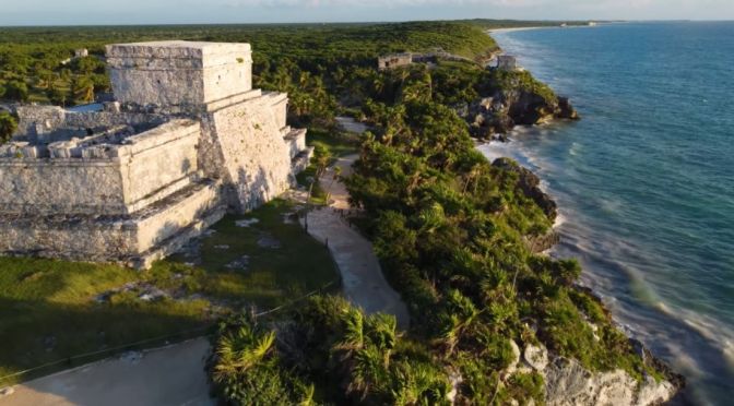
Aerial Views: Yucatán In Southeastern Mexico (4K)
Yucatán, estado (state), southeastern Mexico. Occupying part of the northern Yucatán Peninsula, it is bounded to the north by the Gulf of Mexico, to the east and southeast by the state of Quintana Roo, and to the southwest and west by the state of Campeche. The state capital and chief commercial centre is Mérida.
The state’s relief includes coastal wetlands, semiarid hills and plains, and limestone lowlands dotted with cenotes (water-filled sinkholes). In pre-Hispanic times the peninsula was an Olmec and Maya cultural hearth, as evidenced by the monumental ruins of Chichén Itzá and Uxmal; each has been designated a UNESCO World Heritage site, in 1988 and 1996, respectively. Among the other numerous ruined cities are Chumul, Ek Balam, and Sayil. Strong resistance to the Spanish conquest lasted in the area from 1527 until the 1540s. Yucatán occupied the entire peninsula when it became a state in 1824, but following a series of insurrections, its territory was reduced with the loss of Campeche in 1857 (ratified in 1858) and Quintana Roo in 1902. Later boundary changes reduced the state to its present size.
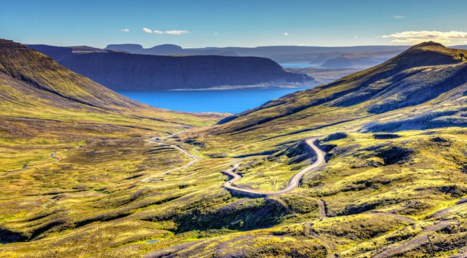
Cinematic Travel: An Epic 30-Day Roadtrip In Iceland
Iceland, island country located in the North Atlantic Ocean. Lying on the constantly active geologic border between North America and Europe, Iceland is a land of vivid contrasts of climate, geography, and culture. Sparkling glaciers, such as Vatna Glacier (Vatnajökull), Europe’s largest, lie across its ruggedly beautiful mountain ranges; abundant hot geysers provide heat for many of the country’s homes and buildings and allow for hothouse agriculture year-round; and the offshore Gulf Stream provides a surprisingly mild climate for what is one of the northernmost inhabited places on the planet.
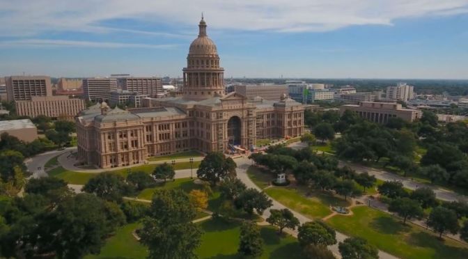
Aerial City Views: Austin – The Capital Of Texas (4K)
Austin is the state capital of Texas, an inland city bordering the Hill Country region. Home to the University of Texas flagship campus, Austin is known for its eclectic live-music scene centered around country, blues and rock. Its many parks and lakes are popular for hiking, biking, swimming and boating. South of the city, Formula One’s Circuit of the Americas raceway has hosted the United States Grand Prix.

Aerial City Views: Wichita In Central Kansas (4K)
Wichita, city, seat (1870) of Sedgwick county, south-central Kansas, U.S. It lies on the Arkansas River near the mouth of the Little Arkansas, about 140 miles (225 km) southwest of Topeka. The city site is a gently rolling plain at an elevation of about 1,300 feet (400 metres). Summers are hot and winters cool; precipitation is moderate and falls mainly during the warm months.
Wichita, the largest city in the state, is at the heart of a three-county metropolitan area. Nearby communities include Park City (north), Andover (east), and Derby and Haysville (south). Inc. city, 1871. Area city, 139 square miles (360 square km). Pop. (2010) 382,368; Wichita Metro Area, 623,061; (2020) 397,532...
Wichita was founded in 1864 as a trading post on the site of a village of the Wichita Indians. It owed its early development to the Texas cattle trade along the Chisholm Trail and to the rapid spread of agricultural settlement along the Atchison, Topeka and Santa Fe Railway, then under construction. In its early years Wichita was a stopover on cattle drives to Abilene (Kansas) and other points as the railroad moved west; in 1872 the line reached Wichita, and the city became a major cattle-shipping centre. By 1875 farmers’ fences were obstructing the movement of beef herds, but grain became an important commodity.
