
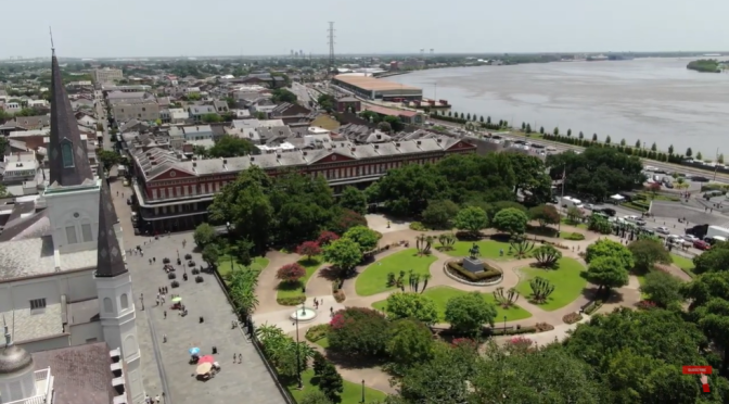
New Orleans is a Louisiana city on the Mississippi River, near the Gulf of Mexico. Nicknamed the “Big Easy,” it’s known for its round-the-clock nightlife, vibrant live-music scene and spicy, singular cuisine reflecting its history as a melting pot of French, African and American cultures. Embodying its festive spirit is Mardi Gras, the late-winter carnival famed for raucous costumed parades and street parties.
Tag Archives: Aerial Views

Views: Zanzibar Island, Tanzania, East Africa (4K)
Zanzibar, Swahili Unguja, island in the Indian Ocean, lying 22 miles (35 km) off the coast of east-central Africa. In 1964 Zanzibar, together with Pemba Island and some other smaller islands, joined with Tanganyika on the mainland to form the United Republic of Tanzania. Area 600 square miles (1,554 square km). Pop. (2007 est.) 713,000.
Before the development of eastern African mainland ports, Zanzibar was the trade focus of the region and enjoyed an important entrepôt trade. The island’s economy now depends on agriculture and fishing. Considerable areas of fertile soil and a favourable climate enable the production of a variety of tropical crops, most importantly cloves and coconuts. Local food crops, such as rice, cassava, yams, and tropical fruit, are also important. Fish is an important part of the diet, and local fisheries employ perhaps about one-tenth of the population.

Views: Winter Landscapes From Around The World

Views: San Felipe Creek In Southwestern Texas
Fly above San Felipe Creek and the Rio Grande at the golden hour before sunset.
The Rio Grande, known in Mexico as the Río Bravo del Norte and as the Río Bravo, is one of the principal rivers in the southwestern United States and in northern Mexico. The length of the Rio Grande is 1,896 miles and originates in south-central Colorado, in the United States, and flows to the Gulf of Mexico.
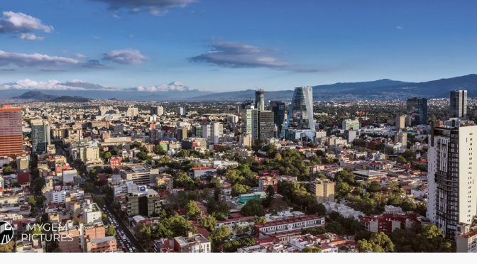
Aerial Views: Mexico City – Capital Of Mexico (4K)
Mexico City is the densely populated, high-altitude capital of Mexico. It’s known for its Templo Mayor (a 13th-century Aztec temple), the baroque Catedral Metropolitana de México of the Spanish conquistadors and the Palacio Nacional, which houses historic murals by Diego Rivera. All of these are situated in and around the Plaza de la Constitución, the massive main square also known as the Zócalo.

Views: Lake Lugano In Southern Switzerland
Lake Lugano is a glacial lake which is situated on the border between southern Switzerland and northern Italy. The lake, named after the city of Lugano, is situated between Lake Como and Lago Maggiore.

Aerial Views: Landscapes And Cities Of Spain (4K)
Spain, a country on Europe’s Iberian Peninsula, includes 17 autonomous regions with diverse geography and cultures. Capital city Madrid is home to the Royal Palace and Prado museum, housing works by European masters. Segovia has a medieval castle (the Alcázar) and an intact Roman aqueduct. Catalonia’s capital, Barcelona, is defined by Antoni Gaudí’s whimsical modernist landmarks like the Sagrada Família church.
Aerial Views: Kamchatka Peninsula, Eastern Russia
Kamchatka Peninsula, also spelled Kamčatka, Russian Poluostrov Kamchatka, peninsula in far eastern Russia, lying between the Sea of Okhotsk on the west and the Pacific Ocean and Bering Sea on the east. It is about 750 miles (1,200 km) long north-south and about 300 miles (480 km) across at its widest; its area is approximately 140,000 square miles (370,000 square km).
Two mountain ranges, the Sredinny (“Central”) and Vostochny (“Eastern”), extend along the peninsula and rise to 15,584 feet (4,750 metres) in Klyuchevskaya Volcano. The trough between these mountain chains is occupied for much of its length by the Kamchatka River. Of the 127 volcanoes, 22 are still active, as are a number of geysers and hot springs. Most of the active volcanoes lie along a fault line on the eastern flank of the Vostochny Range.
The western coastlands of the Kamchatka Peninsula form a low plain crossed by many rivers and with extensive swamps, while the eastern coast is an alternation of broad gulfs and cliffed, mountainous peninsulas. A small geothermal-power station uses underground steam and is in operation near the southern end of the peninsula.
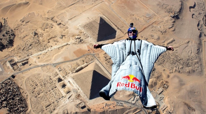
Extreme Views: Wingsuit Flying Over The Pyramids
Flying closer to the great pyramids of Giza than any wingsuit pilots than before, Fred Fugen, Vincent Cotte and Mike Swanson used new wingsuit designs to soar past the Egyptian monuments getting close enough to the Pyramid of Khafre that they could almost touch it. It’s a whole new way to look at history.

Views: Devils Tower In Northeast Wyoming (4K)
Devils Tower is a butte, possibly laccolithic, composed of igneous rock in the Bear Lodge Ranger District of the Black Hills, near Hulett and Sundance in Crook County, northeastern Wyoming, above the Belle Fourche River. It rises 1,267 feet above the Belle Fourche River, standing 867 feet from summit to base.
